| |
|
Vocabulary:
- contour
- coordinates
- longitude
-
latitude
- topographic
maps
- atlas
of Australia/Queensland
- journal/pencil
|
 |
Preparation:
- Create
a three column KWL chart in student journal for WHAT I KNOW,
WISH TO KNOW, WHAT I LEARNED.
- Study
topography maps and compare them to atlas maps of the same
region.
- Discuss
in your group the differences between maps of a region.
-
Topography
maps provide information about the landforms in a particular
section of the country. They give us longitude and latitude
readings for location of place, plus elevation indicated by
contour lines.
-
Discuss
in your group how this information would be useful to people
traveling cross-country. What would you look for as far as
landmarks that would make your trip easier? Would location
of water be important? How would distance between supply stops
affect your travel plans?
-
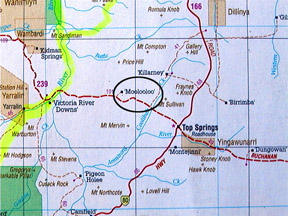
Using
three topography maps, locate, using long/lat coordinates,
three different locations. List the names of the locations
and guess how they might relate to Expedition 360’s travel
through mining areas from Cooktown to the Palmer River region
and beyond.
-
Using
the following coordinates, identify place names, and record
your findings in your journal:
|
145
degrees 01’E
|
14
degrees 48’ S
|
|
138
degrees 20’E
|
21
degrees 36’S
|
|
130
degrees 51’E
|
12
degrees 28’S
|
Analyze
and Conclude:
-
Each
student write a summary of their findings concerning location
of place using longitude and latitude coordinates.
-
Identify
place names of the coordinates, then analyze why you believe
towns/settlements developed in those locations.
-
List
available resources that document ideas as to why a community
would prosper, i.e. settlers from diverse ethnic backgrounds,
climate, weather, etc, discussing in your journal how each would
affect community growth.
|
|
 |