Introduction:
Have
you ever wondered how high a hill is? In this activity you will
investigate how early geologists made accurate estimates of the
height of mountains. You will also learn the skill of ‘leveling’
to determine slope.
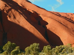
In the
background for this lesson, we learned how far one has to travel
to measure the circumference of the base (8.8 km) of the monolith
Uluru. We also learned the percent of the steepness of the sides.
(Compare that to a 7% grade a highway travels over a mountain pass!)
The height of Uluru is approximate to that of the Eiffel Tower.
How do scientists and mathematicians
figure out the height of a mountain? Experiment with the ancient
art of ‘leveling’ to figure the height of a slope.
Vocabulary:
- kilomometres
- Geological
- monolith
- summit
- traverse
- circumference
Materials:
- quart
size (946 ml) glass jar with lid, half full of water
- wide
rubber band
- pointed
stick about 2 feet (61 cm) long
- journal,
pencil, tape measure
Preparation:
- Locate
a suitable slope to measure with a partner.
- Make
sure you understand how to measure distance using a proper unit
of measure
- Measure
the distance between your eyes and the ground as you will need
this number to compute the slope’s height.
Procedure:
- Place
the jar of water on a level table or level ground. When the water
is still, place the rubber band around the exact level of the
water.
- Stand
at the bottom of the slope you wish to measure. Hold the jar directly
in front of your eyes and look straight across the water. (Make
sure the water level and rubber band are in the same place)
- As
you look through the water level, find a place on the slope and
ask your friend to place the stick there as a mark.
- Record
‘1’ in your journal.
- Climb
the slope and stand where the stick is touching the ground. Place
your feet on either side of the spot, look through the jar until
the water is level for the next place on the slope to mark. Your
friend should move to the new spot and mark it. Record ‘2’
in your journal.
- Repeat
the previous step until you are at the top of the hill or as far
as you wish to measure.
- Add
all of your marks and record the sum in your notebook.
- Use
the tape measure to find the distance between your eyes and the
ground. Multiply the number of marks you recorded by the distance
between your eyes and the ground. The answer is the height of
the slope you measured.
Analyze
and Conclude:
- Were
you able to work cooperatively with a partner to measure the height
of a slope? Were the measurements accurate?
- Were
the recordings in your journal descriptive? Did they describe
the steps needed to find the height of a slope?
- Investigate
modern methods of measuring mountain height. How do they contrast
and compare to ‘leveling’? Which is more accurate? Why
is one method preferable to another?
- Suggest
alternative methods to measuring a slope. Conduct an experiment
to see if the new method is accurate.
Management
Tip: use the print feature
in your browser to print this page.
|