
|
|
|
Activities
|
Extensions
|
|
|
|
Background
|
Related
Links
|
Activity
Title: 'Where in the World'
Subject
Area: Geography
Grade
Levels: 5th + 6th
|
Using
an atlas or topography map, students will locate the cattle
station Moolooloo.
Practical
application of this activity can be a whole class lesson or
incorporated into one of several classroom stations. As a
group activity, students may work ingroups of two-five members.
It is recommended to comprise each group of a range of abilities
and learning levels.
|
 |
Close
monitoring of these groups keeps a balance within the group participation
so that one student is notdominate in completing the work at the
station while others are uninvolved.
Each
member is required to document work completed in their journals
with feedback and calculations. The groups are given twenty minutes
per station to complete their research and work before moving on
to the next station.
Materials:
- Classroom
atlas/map of the Northern Territory of Australia
- Topographic
map
- Journal
for recording data
|
Background
and Procedure:
Topography
maps provide information about the land forms in a particular
section of the country. They give us longitude and latitude
for location of place, plus elevation indicated by contour
lines. Through the use of these maps, certain characteristics
of place may become evident, i.e., hilly regions, mountainous
areas.
|
 |
Discuss
in your group how this information would be useful to people traveling
cross-country. What would they look for as far as landmarks that
would make the trip easier. Would location of water be important?
What if you are an early day pioneer and have livestock? How would
distance between supply stops affect your travel plans?
Analyze
and Conclude:
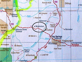
Using
a topographic map or an atlas of the Northern Territory, locate,
using longitude/latitude coordinates, the location of Moolooloo
cattle station. List the names of the nearest location for supplies
and guess how these supply points might relate to Expedition 360’s
travel across Australia.
Moolooloo
coordinates: 16 degrees 20’ S. 131 degrees 27’ E
Lesson
Extensions:
Recreate
the cattle trail that Nat Buchanan followed when he first brought
cattle to the ‘transition zone’ (grasslands between the
deserts of the southern region and the tropical Top End) of the
Northern Territory. Using a map and long/lat coordinates, plot points
of his departure to the east. Then, list the various stops he made
along the way.where the large cattle herds were to be used to stock
the early cattle stations.
N.B.
Teachers please note that this lesson activity relates to the 'Background
to Activity' section in Discovery Zone # 15: 'Ringer for a Day'.
|
