Australia Lesson Activities - Geographytag:www.expedition360.com,2007:/australia_lessons_geography//202007-04-27T09:15:16ZGeography lessons sent from the Outback by the Overland Australia team of Expedition 360 for use by classrooms worldwide free of charge.Movable Type 3.35Bird and Migrationtag:www.expedition360.com,2001:/australia_lessons_geography//20.9212001-10-17T09:12:46Z2007-04-27T09:15:16ZTHEME: Birds SUBJECT AREA: Geography TOPIC: Migration 2001 October 17, Wednesday If you have been keeping up with us this far you probably know a little about the Wet and the Dry. --Seasons, that is. The Wet is when the...jasonwww.expedition360.com
Many other transformations are beginning to take place to make the place appealing for these tourist birds as well. The Wet season is when large flying insects are at their peak. This is hard to resist for the dollarbirds. Native fruits become more common, too, which has the common koel and the channel-billed cuckoo just salivating all the way from New Guinea and Indonesia. When it’s back to the Dry season again, some of these birds will be packing up and heading north for better dining.
Shorebirds will also be at their most common as the top of Australia gets soaked again. Wading birds like the curlew, knots, sandpipers and plovers are forced to go south from as far away as Siberia because it’s just getting too cold for them up there. When they land in Darwin or Kakadu National Park, they may have been flying for up to 72 hours and hit the ground eating when they land (just like Crister does when he stops biking).
We’re at the end of the Dry now, a time when this area sees a lot of activity from the native Australian birds as well as the out-of-towners. It’s the time when the swamps and billabongs have receded to their utmost. Thousands of native water birds are starting to arrive to enjoy the easy pickings underneath—platters of crustaceans, amphibians and fish or, for the vegetarians, wild rice and rushes as they prefer. These birds include whistling ducks, magpie geese, the Jabiru stork and the pied heron.
Darwin is only a stopover point for some of these birds, a place for a little rest. Some plan to fly all the way to the bottom of Australia to make their home until the Dry moves in and it’s time to turn around and go north again.
Suggested learning activities: Find out what types of birds make their way past your house over the course of the year. Why might you see them there when they do?
todd
]]>
Pine Creek Region - The Wet Seasontag:www.expedition360.com,2001:/australia_lessons_geography//20.9182001-10-16T08:52:13Z2007-04-27T08:59:39ZTHEME: Pine Creek Region SUBJECT AREA: Geography TOPIC: The Wet Season The weather in Australia is almost in reverse to the weather in the Northern Hemisphere. When it is winter down here in Australia it would be summer in Europe....jasonwww.expedition360.com
Comparing rainfall from the more arid Alice Springs to the tropical Darwin you will notice a major difference. From November, December, January, February and March (the wet), average rainfall is around 1290 mm in Darwin, compared to Alice Springs at 190mm. The dry season in Darwin has an average of 22mm, compared to Alice Springs at 39mm. The Monsoon Trough that passes through the tropical climates during the summer months, bringing consistent rain, storms and occasionally cyclones, can explain the dramatic difference in the two towns.
In Australia there is a competition called the Golden Gumboot (wellington boot), a competition of the town that records the most rainfall. Two towns in North Queensland always fight over who gets the most rainfall. These two towns - Mirriwinni and Tarzali - are on opposite sides of a mountain range. It would not be uncommon for either town to record up to 3000mm of rain in one year.
Suggested activities: Examine annual rainfall amounts in your area. Which season has the heaviest rainfall amounts? Explain how the local geography plays a role in affecting yearly rainfall. Why do locations on one side of a mountain range get more or less rain?
Feed your children wheat. Joshua.
]]>
Limestone Gorge - Stromatolitestag:www.expedition360.com,2001:/australia_lessons_geography//20.8982001-10-08T06:58:03Z2007-04-27T07:00:36ZTHEME: Limestone Gorge SUBJECT AREA: Geography TOPIC: Stromatolites On our past weekend, we got to have two full layover days, or rest days at Limestone Gorge. Its rock walls, swimming hole, and beautiful hikes were taken in fully by myself,...jasonwww.expedition360.com
They are formed in shallow seas or lagoons when millions of cyanobacteria (primitive bacterial life forms) colonise together in a cabbage shaped growth. Filaments, poking out from the bacteria trap sediment and eventually become fossilized, thus creating stromolites.
At Limestone Gorge there are a lot of stromatolites at the Skull Creek formation. They are way cool to see and understand what you are really looking at!
They can be found under the earth about 20 metres and are sometimes exposed by the elements like here at Limestone Gorge, so we can see them!
Suggested learning activities: Investigate unusual rock formations and types of rocks in your area. How were they formed and from what type of geographical feature? Was your area once an ocean or a shallow sea? What fossil evidence might indicate this?
Crister
]]>
Gregory National Park regiontag:www.expedition360.com,2001:/australia_lessons_geography//20.8912001-10-02T06:26:28Z2007-04-27T06:29:15ZTHEME: Gregory National Park SUBJECT AREA: Geography TOPIC: geography of the Gregory National Park region 2001 October 2, Tuesday. Gregory National Park, Bullita Sector. Gregory is a relatively new national park, officially listed in 1990, and incorporates two separate parks,...jasonwww.expedition360.com
The Northern Territory has more than one hundred listed national parks and reserves covering 4.4 million hectares (10.8 million acres), and 229 000 hectares (565 900 acres) of marine parks. They are administered by the Parks and Wildlife Commission of the NT, except for Kakadu and Uluru-Kata Tjuta, which are World Heritage Listed.
Some of the Northern Territory’s national parks are so isolated and rugged that they attract few visitors, and most only to look. Others are popular recreational areas, and are among Australia’s major attractions. Public Access is encouraged if safety and conservation regulations are observed. See today’s e.s.d. update.
Suggested learning activities:
Discover a national park near your home. Try to answer some of the following:
* How much land does it cover?
* What is unique about its ecosystem?
* What endangered native animals does it protect
* What land systems does it encompass?
* Is it a popular tourist place?
* When was it declared a national park?
* Why was it declared a national park?
Find the national park on a map.
bel]]>
Victoria River Basintag:www.expedition360.com,2001:/australia_lessons_geography//20.8872001-10-01T12:23:47Z2007-04-26T12:27:17ZTHEME: Victoria River District SUBJECT AREAS: Geography TOPIC: Geography of Victoria River Basin The land changed quickly on the way north from Lajamanu today. It was quite noticeable that we’d left the Tanami Desert behind as the spinifex-dotted expanses gave...jasonwww.expedition360.com
We are presently in the western half of the Barkly Region of the Northern Territory. It is the transition zone from the green of the Top End to the red ochre of the centre. The rich Victoria River pastoral district we have entered is predominately cattle country and well suited for it. Imagine our amazement as we crossed Gordy Creek and there was actually water in it! So many of our campsites have been dry over the course of the last several weeks. When we crossed the Victoria River (full of water, I might add!) on our way into Kalkaringi, it was almost sensory overload as water has been so scarce.
As might be expected in this geographic transition zone between the tropical Top End and the arid centre, the rainfall in this region varies markedly, from around 400 mm in the south to well over 1000mm along the coast. Rainfall in the Victoria River district falls somewhere in between, with this spring being an exceptionally wet one (see the photos of the police station; one taken in March this year, the other taken today from the same camera angle). The local citizens in Kalkaringi speak of large thunderstorms developing in the late afternoon and releasing torrents of water. The country we’ve been riding through is a testament to that fact the grass and other vegetation are significantly greener this time of year compared to years past.
Sandstone gorges, high cliffs and flat-top ranges await us in the next few days as we travel toward Gregory National Park. We have definitely entered a new geographic region! And, this evening as we crossed the Victoria River leaving Kalkaringi, we discovered a made-to-order water slide! We bailed off the bikes into the cool rushing water as it tumbled over large rock surfaces in the roadbed.
Suggested activities: Compare rainfall amounts and vegetation in your region. What types of plants are best suited to your climate? Does your region’s geography have an impact on the local economy agriculturally speaking, and, if so, how is it impacted? Study the effects of drought in your area. Investigate what is done to compensate for dry seasons.
April
]]>
Geography and Land Ownership Rightstag:www.expedition360.com,2001:/australia_lessons_geography//20.8822001-09-27T10:37:19Z2007-04-26T10:53:40ZAboriginal Rights and GEOGRAPHY Land Rights: Since Alice Springs we’ve been biking through predominantly aboriginal freehold land. This means the land was given back to the traditional aboriginal owners sometime since The Aboriginal Land Rights (NT) Act of 1976, which...jasonwww.expedition360.com
So, how does geography play a part in all this? The brown and white areas we see on a map of the North Territory tells us a lot about the surface ‘value’ of the land in terms of water and the capacity to support livestock (predominantly cattle in this case), and the hidden ‘value’ of the land in the form of mineral and oil deposits. They also give us some clues as to the whereabouts of landforms and geographical features in the landscape that are considered sacred by local aboriginal ‘guardians’. The reasons for both are as follows:
When the Aboriginal Land Rights (NT) Act was passed in 1976, the only land allowed to be claimed was land outside town boundaries and that not already owned or leased by anybody else. This, for the most part, meant either semi-desert or desert as any ‘valuable’ land with water on it (in the form of springs or bores) or vegetation that could support cattle on it, would already be spoken for. So, you could say that only land that was useless to the settlers would be given back, as a form of tokenism to defuse the rising pressure the government was facing from aboriginal groups seeking Land Reform from WW2 on. The brown areas therefore largely represent desert regions of little economic use, whereas the white areas represent pastoral leases on land that has water or is in some other way of economic value to the people farming it.
Sacred sites are also key to the whole Land Rights Issue, as one of the conditions for land to be given back to its traditional aboriginal owners under the Aboriginal Land Rights (NT) Act is that a claimant has to prove under aboriginal law that they are responsible for the sacred sites on the land being claimed. Such sacred sites represent evidence of a dreamtime ancestor having passed that way and left some mark: a pile of stones or even a tree. Some sites are very obvious – like Uluru (Ayers Rock). Others are less so and might not even be visible to the human eye. So the geography of the landscape is very often instrumental for determining whether a piece of land is returned to its traditional aboriginal owner or not.
We can conclude therefore that by looking at a Land Ownership map of North Territory we can make some rough guesses as why certain areas are coloured the way they are and what assets – either economic or religious – the land holds.
Suggested Learning activities: research an example of land ownership conflict in your local area and make some calculated guesses as to what ‘value’ the land represents to the interested parties and for what reasons they might therefore be in conflict with each other.
]]>
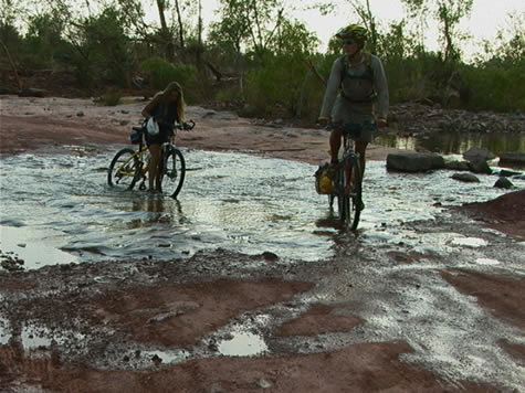
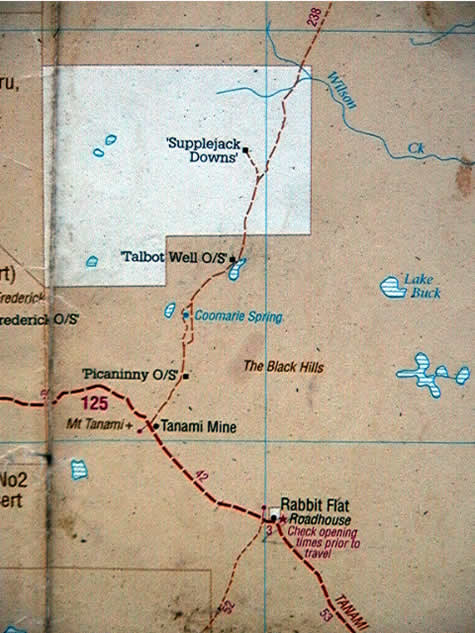
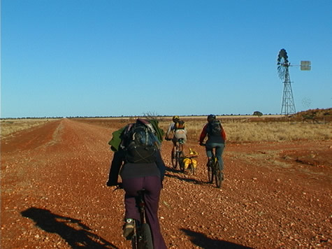
Extreme Climates - The Tanami Deserttag:www.expedition360.com,2001:/australia_lessons_geography//20.8702001-09-24T08:23:54Z2007-04-26T08:28:07ZGeography – Tanami desert The beginning of the Tertiary period in the earth’s history was typified in central Australia by high temperature, rainfall and silcrete formation in extensive low-lying inland areas such as the Tanami Desert. This resulted in the...jasonwww.expedition360.com
So why is the Tanami Desert flat but not so the Macdonell Ranges to the South and The Kimberly to the Northwest? One theory is that the Tanami forms a pivot around which a gigantic block of the earth’s crust rotated forming mountains (Macdonell Ranges) and a trough (The Kimberly). The central Tanami area – being the pivot – has therefore avoided any influence from uplifting or tearing of the earth’s crust.
This flat terrain promotes a semi-arid climate, as any moisture from rainfall perculates quickly through the upper strata of sandy soil. Also, any influence from the ocean in the form of moist air, for example, is minimal. However, fluctuations in global weather patterns can affect the geography and ecology of the region quite considerably, making it possible for a non-indigenous species – like the rabbit – to thrive so well as it has in the past (hence the name Rabbit Flat where we spent most of today laying up from the midday heat). For example, for the past 3 x years Australia has been experiencing unsually wet conditions, with higher than average rainfall. This has led to there being far more vegetation that we expected. Instead of miles and miles of bare sand dunes we’ve been treated to quite a varied desert-scape rich in spinifex, desert oaks, acacias and mulga trees.
Suggested learning activities: examine a region in your country that is subject to quite extreme climatic conditions. Investigate how fluctuations in weather conditions have affected the region’s geography and/or ecology.
]]>
The Geography of Gosse's Blufftag:www.expedition360.com,2001:/australia_lessons_geography//20.8552001-09-16T14:27:41Z2007-04-25T14:31:09ZGeography – day 55 While biking on the road from Hermannsburg we explored an incredible feature in the landscape: Gosse Bluff; a 5km wide crater thought to have been formed by the impact of comet slamming into the earth’s surface...jasonwww.expedition360.com
The shallow depth of the blast lends weight to the theory of either a comet, or a low-density asteroid and not a solid rock meteorite. However, no trace of a comet or asteroid was been found in the area, and it is presumed to have vapourised.
The blast has been calculated to have been about one million times more powerful than the Hiroshima bomb. It would have destroyed most life forms within a distance of hundreds of kilometres and sent huge plumes of fine debris into the atmosphere, affecting weather patterns worldwide for some years. This would certainly have made for a very challenging environment for plant and animals species seeking to recolonise the surrounding area after the event.
During the blast, fragments of rock, included blocks up to a hundred metres long, were hurled into the air and then fell back to the ground.
The comet would have consisted of a frozen ball of carbon dioxide, ice and dust. Late Proterozoic-Cambrian Rock, 500-800 years old and comprising sandstone, siltstone, shale and limestone, would have been blasted to the surface from more than 6km down. Using satellite imagery we can estimate the original outer crater being up to 20km in diameter. A long period of erosion and wet climate has have since removed this almost entirely, leaving the inner crater of 5km that we see today (see photo).
There is a close parallel with craters that can be found on the surface of the moon and Mars. Similarities are the breaking up and bending of rock layers with in a roughly circular area, a crater, uplifted rock in the centre, shatter cones, melted rock fragments, and minerals that are formed only at extreme pressures.
Suggested learning activities: look at how volcanoes are formed and explore the differences and/or similarities to the impact of extra-terrestrial bodies into the earth’s surface (like at Gosse Bluff).
]]>
Landforms - Corroboree Rocktag:www.expedition360.com,2001:/australia_lessons_geography//20.8472001-09-04T13:48:34Z2007-04-25T13:50:25ZJust off the Ross Highway, some kilometres northeast of the Emily and Jessie Gaps, is a weathered, rippled rock called Corroboree. It began to be formed some 800 million years ago when a shallow, salty sea laid down a fine...jasonwww.expedition360.com
The movement of the earth caused the folding of strata (layers) of rock into the vertical plane, causing the original horizontal layers to stick straight up out of the earth in the form of a ridge. Wind, rain and sun gradually wore down the ridge, with only Corroboree, a particularly hard section of rock, remaining today.
The three predominant colours in the rock are black, orange, and white. The black colour comes from the oxidation of iron particles within the stone, and the orange and yellow are the result of tropical weather conditions.
Suggested learning activities: Identify an example of weathering of a geological feature in your local area. Compare and contrast the weathering forces (sun/rain/wind etc) to those operating on Corroboree.
Git]]>
Geology & Heat Conductiontag:www.expedition360.com,2001:/australia_lessons_geography//20.8402001-09-03T13:23:14Z2007-04-25T13:27:07Z2001 September 3, Monday. Bluff Camp Ground. As we rode between Ross River Homestead and Trephina Gorge Nature Park yesterday evening, the moonlight showed clearly the silhouettes of craggy rock peaks, though the road snaked gently through the broad valley...jasonwww.expedition360.com
First the eastern aspects of the hills, which have already been in shadow for some hours, begin to chill. Creek beds follow closely after, because of the moisture from underground sources, and the protection offered by the vegetation including river red gum trees. West facing slopes and dry exposed earth reach a higher temperature throughout the day, and take longer to cool after sunset.
The various times taken for these features to release their solar heat create these pockets of different temperature air, and the still of these winter evenings combined with the protection offered by the mountains prevents the temperatures between them from equalising quickly.
Because of this system, the earth has lost all of its stored heat by dawn, and the burning heat of each day begins with a cool morning – sometimes approaching freezing point. This is the time we do our most efficient biking, and the main reason we tried a night ride.
Go for a walk out of doors and feel the temperature of different objects, both in and out of direct sunlight. Try grassy and open ground, a tree trunk, a concrete surface and a piece of metal. Which objects conduct more heat? Write down your observations.
bel]]>
The Huckitta Land Systemtag:www.expedition360.com,2001:/australia_lessons_geography//20.8302001-08-29T11:50:21Z2007-04-25T11:52:20ZWednesday 2001 August 29. North of Claraville Homestead. Having passed the ‘Huckitta’ Station turn off earlier in the day, it was interesting to learn that the foothills we are now entering is called a Huckitta Land System. “The Huckitta Land...jasonwww.expedition360.com
Climbing a few of these rocky hillocks yesterday evening gave a terrific demonstration of how the aspect (direction a slope faces in relation to the sun) even of small dry hillocks, impacts the vegetation which will grow there. The sunny side of a hill (in Australia this is the north) is hotter and drier than the slope which is shaded during midday heat. This is true for mountains thousands of metres high, right down to large boulders on relatively flat land. Liverwort will assert itself on the hospitable side of a rock only, and it is possible to find direction by observing this.
The shaded side of a slope causes a number of environmental conditions to vary. Some of the most noticeable include the amount of precipitation received, the change in humidity levels, the temperature difference, and the amount of solar energy available. Different plants thrive under these different conditions.
Over many years, larger amounts of water and sunlight have an effect on soil composition, by encouraging organic matter to grow and break down in the earth, enriching it, and increasing the variety of plants able to grow in those areas.
Think about how your household’s food scraps (organic waste) is disposed of. If you have a garden, suggest to your parents that you begin composting. If you have a compost heap already, find out how it works, and who maintains it. Adding compost to your garden will allow you to grow plants including vegetables which otherwise would not thrive in the same space.
bel.
]]>
Geology & The MacDonnell Rangetag:www.expedition360.com,2001:/australia_lessons_geography//20.8252001-08-28T11:29:41Z2007-04-25T11:31:32ZThe MacDonnell Range we entered today is a freak of Australian geography in so much that it is the only mountain range in Australia that runs east west. All the other ranges run north south. Approximately 850 million years ago...jasonwww.expedition360.com
Approximately 850 million years ago a shallow sea covered the whole area. Then approximately 600 million years ago the range was formed from the flat land sliding vertically during land movement.
During heavy rainfalls, water carves the rock causing widespread erosion over the mountains, leaving amazing rock formations through the range. If the rock hadn’t been washed away over the years the MacDonnell range would be about as big as the Rocky Mountain range in Canada.
Feed your children wheat. Joshua.
]]>
Northern Territorytag:www.expedition360.com,2001:/australia_lessons_geography//20.8102001-08-23T10:10:04Z2007-04-25T10:13:08ZThe sign said ‘Welcome to the Northern Territory of Australia: Nature Territory’ as Mike and I passed, leaving behind Queensland and crossing into the Northern Territory. A contrast between what we’ve left behind and what we have to look forward...jasonwww.expedition360.com
The area of Queensland at 1,727,200 square kilometers, makes up 22% of the Australian continent. Green, productive lush rain forests, fields of sugar cane, and national parks on the east between the Great Dividing Range and the Coral Sea, give the tourist industry an outlet to the Great Barrier Reef. To the west of the Great Dividing Range, vast areas of agricultural land rich in volcanic soils comprise the tablelands.
Perhaps the region that we’ve spent the most time cycling through is the vast outback that lies inland. It fades into the Northern Territory to the west. Rain can make this arid region bloom, but it’s a land of sparse population, long empty roads and tiny distant settlements.
We’ve seen examples of the collection and storage of water from the Great Artesian Basin, created over a period of 2.5 million years as water gradually seeps westward from the Great Dividing Range. It fills approximately 7500 artesian wells that provide the only source of continual water for huge cattle stations. The Wet season does provide a variation on this theme as countless dry river beds become swollen creating a network of waterways which can make travel impossible.
By contrast, the Northern Territory makes up 17% of the Australian landmass, an area of 1.35 million square miles. Although about 80% of the Territory is in the tropics, as the Tropic of Capricorn bisects the continent north of Alice Springs, only the northern 25%, known as the Top End, resembles a tropical climate. There, savannah woodlands and occasional rainforests are in direct contrast to the desert, semi-arid plain in the southern three-quarters to the south.
Today we have slipped through the door to the Northern Territory. Alice Springs, to the southwest, awaits us as we journey toward the Red Centre.
Suggested activities: Compare regions where you live, i.e., climate, temperature averages, rainfall, topography. Investigate the reasons why these regions vary in contrast to each other. Identify mountain ranges and plateaus, which influence rainfall amounts. Discuss how is agriculture affected by climate and what types of crops/livestock are grown near you.
]]>
The Artesian Basin - Origins of Watertag:www.expedition360.com,2001:/australia_lessons_geography//20.8062001-08-22T09:51:58Z2007-04-25T09:54:10ZGeography 22 August 2001 The Great Artesian Basin has had an effect on both the way humans and many animals live in the Outback. For humans it has been a reliable source of water in an area where nothing but...jasonwww.expedition360.com
The troughs of water that the stockmen provide for their cattle help other animals as well. Kangaroos can maintain larger families because of the availability. Flocks of budgerigars (budgies) and other birds can find more places of refuge than they could before people began tapping the water below and bringing it up to storage areas above.
In other arid and semi-arid parts of Australia, away from the Great Artesian Basin, water is often the most limiting factor for the existence of any life, whether human, animal or plant.
Suggested Learning Activity:
Find out where your water comes from.
]]>
Geography of Burke and Wills Expeditiontag:www.expedition360.com,2001:/australia_lessons_geography//20.7872001-08-16T18:15:09Z2007-04-24T18:17:35Z The coast of the Gulf of Carpentaria includes some of Australia’s wildest and most remote country. Before early explorers returned from the area with tales of unparalleled hardships, a plan existed for the coast to harbour a busy port,...jasonwww.expedition360.com
The coast of the Gulf of Carpentaria includes some of Australia’s wildest and most remote country. Before early explorers returned from the area with tales of unparalleled hardships, a plan existed for the coast to harbour a busy port, trading with the wealth of Asia. However, the terrain made any such plan an impossibility.
The Gulf coast is interlaced with hundreds of drainage channels carrying wet season rains away from the flat country farther inland. The flatness of this inland terrain causes the water to sweep across the plains in sheets, or thousands of tiny rivulets, rather than being directed into one or two major rivers. In mountainous country, rivers run only into each other. Here, the land is so flat that water can and does flow out into two or more forks from the one source. This constant fanning out of watercourses, combined with a sheltered coastline and a tropical climate, results in a twisting, jungle lined delta – utterly inaccessible by an overland route to this day.
Burke and Wills discovered at first hand just how challenging (and at times just downright impassable!) the gulf country could be, most notably in the wet season. They were even prevented from completing the last 6 kms to the ocean because of their path being blocked by mangroves. Imagine how frustrating this must have been having just walked 1100 kms! They took the tidal flow in a nearby river as proof of completing their mission – to reach the sea – before turning around and heading back again..
The following is an excerpt from Alan Moorehead’s ‘Coopers Creek’.
“They had struck the wet season; day after day the warm rain poured down, and the camels hated it. They foundered around in the boggy ground, moaning and groaning, and Billy the horse grew very weak. Something like 170 miles still divided them from the sea, and they followed the Cloncurry River downstream to the point where it joined the Flinders River….by the end of January they had reached the Flinders River, and were moving slowly down the Byrno, which was one of its outlets to the sea. The mud was frightful.”
Suggested learning activities:
- research other examples of flood plains either in Australia or another country. Make a comparison between how rivers behave in a flood plain versus a mountainous terrain. Draw pictures where appropriate.
]]>
 Sandstone gorges, high cliffs and flat-top ranges await us in the next few days as we travel toward Gregory National Park. We have definitely entered a new geographic region! And, this evening as we crossed the Victoria River leaving Kalkaringi, we discovered a made-to-order water slide! We bailed off the bikes into the cool rushing water as it tumbled over large rock surfaces in the roadbed.
Suggested activities: Compare rainfall amounts and vegetation in your region. What types of plants are best suited to your climate? Does your region’s geography have an impact on the local economy agriculturally speaking, and, if so, how is it impacted? Study the effects of drought in your area. Investigate what is done to compensate for dry seasons.
April
]]>
Sandstone gorges, high cliffs and flat-top ranges await us in the next few days as we travel toward Gregory National Park. We have definitely entered a new geographic region! And, this evening as we crossed the Victoria River leaving Kalkaringi, we discovered a made-to-order water slide! We bailed off the bikes into the cool rushing water as it tumbled over large rock surfaces in the roadbed.
Suggested activities: Compare rainfall amounts and vegetation in your region. What types of plants are best suited to your climate? Does your region’s geography have an impact on the local economy agriculturally speaking, and, if so, how is it impacted? Study the effects of drought in your area. Investigate what is done to compensate for dry seasons.
April
]]>
 Sacred sites are also key to the whole Land Rights Issue, as one of the conditions for land to be given back to its traditional aboriginal owners under the Aboriginal Land Rights (NT) Act is that a claimant has to prove under aboriginal law that they are responsible for the sacred sites on the land being claimed. Such sacred sites represent evidence of a dreamtime ancestor having passed that way and left some mark: a pile of stones or even a tree. Some sites are very obvious – like Uluru (Ayers Rock). Others are less so and might not even be visible to the human eye. So the geography of the landscape is very often instrumental for determining whether a piece of land is returned to its traditional aboriginal owner or not.
We can conclude therefore that by looking at a Land Ownership map of North Territory we can make some rough guesses as why certain areas are coloured the way they are and what assets – either economic or religious – the land holds.
Suggested Learning activities: research an example of land ownership conflict in your local area and make some calculated guesses as to what ‘value’ the land represents to the interested parties and for what reasons they might therefore be in conflict with each other.
]]>
Sacred sites are also key to the whole Land Rights Issue, as one of the conditions for land to be given back to its traditional aboriginal owners under the Aboriginal Land Rights (NT) Act is that a claimant has to prove under aboriginal law that they are responsible for the sacred sites on the land being claimed. Such sacred sites represent evidence of a dreamtime ancestor having passed that way and left some mark: a pile of stones or even a tree. Some sites are very obvious – like Uluru (Ayers Rock). Others are less so and might not even be visible to the human eye. So the geography of the landscape is very often instrumental for determining whether a piece of land is returned to its traditional aboriginal owner or not.
We can conclude therefore that by looking at a Land Ownership map of North Territory we can make some rough guesses as why certain areas are coloured the way they are and what assets – either economic or religious – the land holds.
Suggested Learning activities: research an example of land ownership conflict in your local area and make some calculated guesses as to what ‘value’ the land represents to the interested parties and for what reasons they might therefore be in conflict with each other.
]]>
 By contrast, the Northern Territory makes up 17% of the Australian landmass, an area of 1.35 million square miles. Although about 80% of the Territory is in the tropics, as the Tropic of Capricorn bisects the continent north of Alice Springs, only the northern 25%, known as the Top End, resembles a tropical climate. There, savannah woodlands and occasional rainforests are in direct contrast to the desert, semi-arid plain in the southern three-quarters to the south.
Today we have slipped through the door to the Northern Territory. Alice Springs, to the southwest, awaits us as we journey toward the Red Centre.
Suggested activities: Compare regions where you live, i.e., climate, temperature averages, rainfall, topography. Investigate the reasons why these regions vary in contrast to each other. Identify mountain ranges and plateaus, which influence rainfall amounts. Discuss how is agriculture affected by climate and what types of crops/livestock are grown near you.
]]>
By contrast, the Northern Territory makes up 17% of the Australian landmass, an area of 1.35 million square miles. Although about 80% of the Territory is in the tropics, as the Tropic of Capricorn bisects the continent north of Alice Springs, only the northern 25%, known as the Top End, resembles a tropical climate. There, savannah woodlands and occasional rainforests are in direct contrast to the desert, semi-arid plain in the southern three-quarters to the south.
Today we have slipped through the door to the Northern Territory. Alice Springs, to the southwest, awaits us as we journey toward the Red Centre.
Suggested activities: Compare regions where you live, i.e., climate, temperature averages, rainfall, topography. Investigate the reasons why these regions vary in contrast to each other. Identify mountain ranges and plateaus, which influence rainfall amounts. Discuss how is agriculture affected by climate and what types of crops/livestock are grown near you.
]]>