« Solomons to Australia voyage - Update #5 | Main | Solomons to Australia voyage - Update #7 »
July 24, 2000
Solomons to Australia voyage - Update #6

Lat/Long as of 11.57hrs local time
10 degs 39. 26’ S
156 degs 51. 46’E
Day 7.Wind SE 10-15 knots. Heading 195M
Tonight marks the completion of the first week of the voyage, but neither of us feels like celebrating. For one we can’t afford to take more than a few minutes off here and there at least until we clear the reef system of the Louisiade Archipelago. Secondly, it has rained more or less non stop for the last 48 hours rendering living conditions aboard quite miserable (there is not one square inch of dry material on or in the boat – see video clip). We long for the sun, for even a hint of blue sky. A gap in the steel grey did appear about 3-4 miles to the east of us about an hour before sundown this afternoon, and our hearts lifted at the sight of it and the thought that we might soon be released from our watery prison. But cruelly the clouds moved back in again, swallowing us once more into the swirling pea soup that has been our home for so long now.
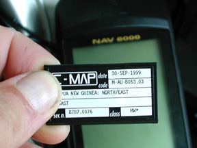
One dilemma that I was wrestling with until today was how to navigate through the Louisade Archipelago reef system should we end up there without any detailed charts of the area. Then I remembered a rather extravagant purchase I’d made before leaving the US earlier this year of some C-Map cards that plug into our Magellan Nav 6000 GPS and provide on-screen charts that can be zoomed into for greater and greater detail on a particular region in question. Each card covers a fair sized region e.g. the whole of Indonesia, so what you are in effect getting for your $350 (for each card) is the equivalent of perhaps 50 or more paper charts but condensed into the size of single chip (see photo). When I stuck in the card for Papua New Guinea and eastern Indonesia – that I’d got more for the kayak leg up from Timor to Singapore next year – I discovered with relief that the Lousiade Archipelago was just inside the outer eastern limit of the area covered. So now I feel a little more confident about nosing our way in and out of the reefs of that area if we have to.
There’s another dilemma I’ve been wrestling with today also, to which I have as of yet come to no solution. Whilst burrowing in the front compartment this morning for some piece of long lost piece of kit carefully squirreled away in there sometime ago I came face to face with a large brown spider; a big wooly looking thing that fixed me for a few seconds with one of its beady black eyes before disappearing at a startling pace into the recesses of one of the food bins. Now I’m not one for spiders - can’t stand them actually. But I know April is even worse. Do I tell her about it and risk her not being able to sleep in there again for the rest of the voyage (unpacking all of the equipment and food mid-ocean is out of the question)? Or do I keep my mouth shut and hope she doesn’t find out for herself? Suggestions on a postcard please.
Jason
Posted on July 24, 2000 2:19 PM