« March 2001 | Main | June 2001 »
April 28, 2001
Overland Australia - overview 3
Route Planner
4 main stages: Tropical Rainforest, Floodplain, Desert and Northern Territories.
Tropical Rainforest: Cape York is about as wild as it gets for Australia. Not too many people realise it but this region of the country is covered in tropical jungle and for five months of the year (November to April) subject to a torrential rainy season making any overland passage impossible.
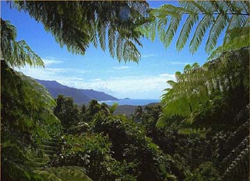
We would plan to start our Australian odyssey at the mouth of the Starke River on the NE coast of Cape York, using the old mining and logging tracks (marked only on highly detailed topographical maps) to wind our way through the dense jungle and up over the Great Dividing Range mountains into the central flood plains.
Flood Plain: Our route will then take us through Lakefield National Park (one of the last refuges of the Cassowary - a huge flightless bird drastically reduced in numbers now to near extinction), Battle Camp (the site of a major battle during the 1873 Palmer River gold rush) and past countless old gold mines (now abandoned) that are the only remaining testament to the frenzied fever of the gold rush that swept through the country back in the 19th and early 20th centuries.

Desert: the central desert of Australia was the arena for countless legendary exploits of the early explorers and pioneers. Take 'Russian Jack' for example, who once carried an injured 'digger' colleague 300 km in his wheelbarrow. Or the gold prospector Harold Lassetter who, in 1930, led an infamous but ill-fated expedition in search of a 'golden reef' in the desert around Uluru. After the camels bolted and an internal dispute split up the group, Lassetter continued on alone but never made it back. His journal - later recovered in the cave where he spent his final days waiting in vain to be rescued - details his discovery and pegging of the reef, but no exact location.
We'll be following in Lassetters's footsteps along the Lassetter Highway toward The Canning Stock Route that leads over a thousand miles across the Great Sandy Desert. At times we can expect for midday temperatures to reach up to 50 degrees Celsius. One of the highlights will be passing around Uluru (Ayers Rock) - the geographical hub of Australia and a spiritual focal point for Aborigines - before heading north towards Darwin.
Northern Territory: before arriving in Darwin we'll pass through Kimberly and Kakadu National Park where over 5,000 Aboriginal rock art sites - some of them over 40,000 years old - can be explored.
Biodiversity:
All along the route we expect to come into contact with a tremendous range of flora and fauna that have been evolving separately from the rest of the world since Australia broke from the southern super-continent of Gondwana over 100 million years ago. The Macdonnell Ranges near Alice Springs for example contain nearly 600 native plant species alone. Apart from dodging the 'salties' (crocs) for the first third of the trip, we'll also be bumping into unique animals such as kangaroos, wallabies, emus, cockatoos, bandicoots, dingoes, and of course a huge array of snakes (two of the most deadly being the Taipan and the Death Adder), spiders and an amazing variety of lizards including various large goannas and dragons.
Posted at 1:41 PM
April 26, 2001
Overland Australia - overview 2
Overland Australia - planning notes
Overland Australia will be a 3,000 mile overland journey by mountain bike from the NE Queensland coast to Darwin on the NW coast, taking in Uluru (Ayers Rock) and many other significant areas of natural beauty, cultural heritage and geographical diversity en route. The overall concept is to avoid the sealed roads and explore the heart of the Australian Outback at ground level: meeting the local people, discovering the tremendous range of indigenous flora and fauna on its own terms. Instead of being laden down with heavy bike saddlebags, we'll look to travel super-light, using GPS (Global Positioning System), compasses and high detail topographic maps to follow the less traveled paths and tracks (see the more detailed 'Route Planner' below). A daily average of 40 miles per day will put the total length of the trip at 100 days.
The concept is to avoid the sealed roads and explore the heart of the Australian Outback at ground level: meeting the local people, discovering the tremendous range of indigenous flora and fauna on its own terms. Instead of being laden down with heavy bike saddlebags, we’ll travel super-light, using GPS (Global Positioning System), compasses and high detail topographic maps to follow the less traveled paths and tracks A daily average of 40 miles per day will put the total length of the trip at 100 days including time off for rest days.
The route will take in an antipodal point (23.47.00S, 131.22.00E), opposite to a sister point Steve and I reached on the Atlantic (23.48.36N, 48.37.37W). This will ensue Expedition 360 fulfills the criteria as delineated by Guinness World Records for a human-powered circumnavigation: crossing the equator into the opposing hemisphere, traversing all lines of longitude, and traveling a minimum distance of the equator.
Because of long distances between water supply points and the dangers from possible heat exposure, fatigue and being bitten by any one of the many venomous creepy crawlies that inhabit the Outback, this form of overland travel will only be possible with backup from a support team.
Sufficient time is also being factored in to visit and share story with 4 x schools en route. Some of these ‘schools’ will be little more than homesteads or ‘stations’ where the kids do their schooling by HF radio, telephone or satellite.
A handful of teenage volunteers in Cairns and Alice Springs are also being invited to participate in a cultural exchange program involving students capturing their world through the eye of a still or video camera and sharing it with other participating groups around the world by album exchanges and posting on the website as a film.
A team of 9 - of varying ages, social and cultural backgrounds - are joining up for this leg. Three teenagers from the US, Australia and the UK will accompany six adults Ð two being teachers. Followers of the Internet updates will be invited to share the daily trials and the tribulations of the team on what will be an incredible adventure through the Australian Outback. Broadband subscribers will be as close to the action without actually being there by accessing live video uplinks sent back from the field via M4 satellite phones.
If you know of any British or Australian teenagers interested in coming along, please email expedition_360@yahoo.com.
Kayak leg: To protect the integrity of using only of human power to circumnavigate the earth, the biking element of Overland Australia will be preceded by a kayak leg (just Jason) from the spot Moksha took a tow through the reef
Sufficient time is also being factored in to visit 3 x schools en route, spending enough time to give multimedia presentations of the expedition so far and introduce students to the expedition's Cultural Exchange programs: A handful of volunteers will then be invited to participate in the World Photo Exchange and Video Exchange, which involves capturing their world through the eye of a camera and sharing it with other participating groups around the world.
TIME FRAME
May 10th 2001 Jason arrives Cairns to start 6 x week preparation.
July 1st Remainder of team arrive.
July 5th Jason kayaks in through the Great Barrier Reef from the point where Moksha was towed August 2000.
July 8th Overland trek starts.
Oct 15th Arrive Darwin.
Posted at 1:39 PM
April 21, 2001
Overland Australia - overview 1
The concept is to avoid the sealed roads and explore the heart of the Australian Outback at ground level: meeting the local people, discovering the tremendous range of indigenous flora and fauna on its own terms. Instead of being laden down with heavy bike saddlebags, we’ll travel super-light, using GPS (Global Positioning System), compasses and high detail topographic maps to follow the less traveled paths and tracks A daily average of 40 miles per day will put the total length of the trip at 100 days including time off for rest days.
The route will take in an antipodal point (23.47.00S, 131.22.00E), opposite to a sister point Steve and I reached on the Atlantic (23.48.36N, 48.37.37W). This will ensue Expedition 360 fulfills the criteria as delineated by Guinness World Records for a human-powered circumnavigation: crossing the equator into the opposing hemisphere, traversing all lines of longitude, and traveling a minimum distance of the equator.
Because of long distances between water supply points and the dangers from possible heat exposure, fatigue and being bitten by any one of the many venomous creepy crawlies that inhabit the Outback, this form of overland travel will only be possible with backup from a support team.
Sufficient time is also being factored in to visit and share story with 4 x schools en route. Some of these ‘schools’ will be little more than homesteads or ‘stations’ where the kids do their schooling by HF radio, telephone or satellite.
A handful of teenage volunteers in Cairns and Alice Springs are also being invited to participate in a cultural exchange program involving students capturing their world through the eye of a still or video camera and sharing it with other participating groups around the world by album exchanges and posting on the website as a film.
Posted at 1:18 PM