« August 2001 | Main | October 2001 »
September 30, 2001
Overland Australia - Update 56
September 30, 2001
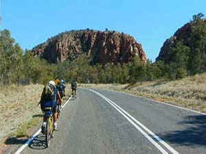
Day 69
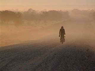
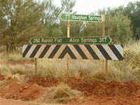
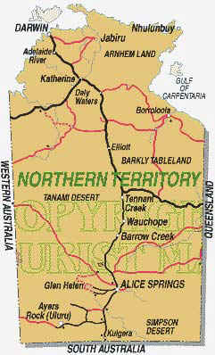
20 kilometres north of Lajamanu
From bel
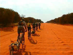
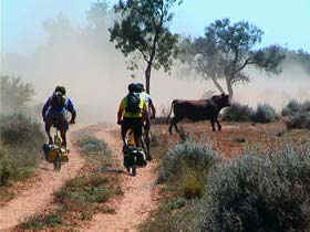
We’re riding toward Gregory National Park in hope of finding standing water and some good exploring ground in which to rest. You can probably gather from yesterday’s general update that our break by the water hole (‘hole’ being the operative word) was an utter failure. Decking flies is much more tiring than riding, and it’s debateable whether the roasting heat is less severe in the spotted shade of sparse desert-fringe trees, than out in the sun with a biking breeze to cool us.
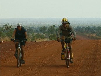
I decided after the first day that Camp Central (or ‘Grong Grong Camp’ – see aboriginal place names below – ed.) was not the place to be all day, and made it known that I would be setting out the next morning to try to make it through to Lajamanu on the old road. Crister, too, was up for the challenge, and we abandoned camp just as the flies were perking up for the morning.
During my wanderings the previous afternoon, I had picked up traces of a disused road heading in the right direction to take us to the community. We soon rediscovered the trail, and in around four hours riding, reached Lajamanu, and the community garage and store. The place was buzzing!
Fifty or so locals were potting about the ‘front yard’ of the only store in town; coming and going, chatting and playing, the old and the young. They made a wonderful and enthusiastic welcome party for a hot pair of bikers who felt just a little like pioneers after pushing our way along a very overgrown piece of trail. After lapping up the very different atmosphere, I left Crister with the bikes to search for treats.
When I returned with tomatoes (a bargain at $1.50 each) Crister was ‘talking’ to an interesting looking resident. Tall and lopsided, he had an intense look in his eyes, but seemed friendly enough. “Uh, this is Stanley,” Crister told me, then whispered: “I can't understand a word he’s saying.” As it was my turn to guard the bikes while he bought an ice cream, he left me to entertain our new friend – or visa versa.
Stanley was using a sign language I recognised. “d-a-r-w-i-n” he said. I gave him my best encouraging look. “d-a-r-w-i-n . . . c-h-i-n-a.” I nodded. By the time Crister returned, Stanley was saying: “China . . . if Kung Fu, fu, fu, fu . . . I am! . . . Mah’met Ali!” here he illustrated with a mime of boxing. “I am! Mah’met Ali!” he repeated.
“He’s Mohammed Ali,” I translated.
“Yeah!” Crister said, turning to Stanley, “You the Man!” This greatly pleased Stanley, who displayed a remarkable arrangement of knotty teeth, before ambling away in his lopsided fashion, still sparring. He had simply wanted to communicate.
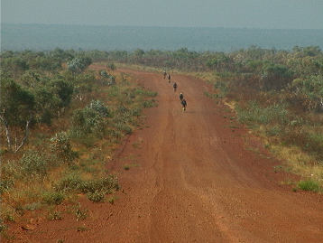
Some time later, our forty-kilometre rest day found us back at camp. We returned along the main road, another sandy, corrugated old thing. The stay-at-homes had perfected the fly-swiping dance to competition level, replete with stamping and shimmying. Crister announced that we had found the way not to go to Lajamanu, unless anyone fancied having an eye taken out by burnt shrubbery. I had been going to suggest the whole team take the back route, but I kept quiet -- I guess he was right.
So this morning we followed a road which just three months ago we would have called a track, but which we now consider to be a main drag. It wound us by a very different Lajamanu, which had shut down for its Sunday rest, then spat us out to the north, toward Kalkaringi and beyond.
Aboriginal place-names of the day:
GRONG GRONG: A Poor Camping Ground, Very Hot
ULOOM: Dry Land
PUNTPUNTPUNDALOO: A Bell-bird
COOMOOROOGUREE: Place where the Edible Grub is found in Grass Trees
COOMBULLNEE: Tail of a Dingo
THULLUNGNETHGIE: Place for Making Spears
Our educational theme for today is "The Road to Lajamanu."
CLASSROOM ACTIVITIES >>
Science
Maths
Education for Sustainable Development
Posted at 2:44 PM
September 29, 2001
Overland Australia - Update 55
September 29, 2001
Day 68
21 kilometres west of Lajamanu
from jason
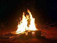
The last couple of days have been much needed layover days, a little R+R after the slog up through the sand of the Tanami desert since leaving Alice Springs 3-weeks ago. The heat was starting to get to us also, adding to the general fatigue felt by all from being on the road for nearly 70 days now. So, at Wednesday’s evening meeting it was decided to halt the expedition at the first suitable camp spot that displayed as many of the necessary criteria for a relatively comfortable stay: shade, water (for washing clothes, bodies and dishes), firewood and an absence of dry grass that might flare up into a Bushfire.
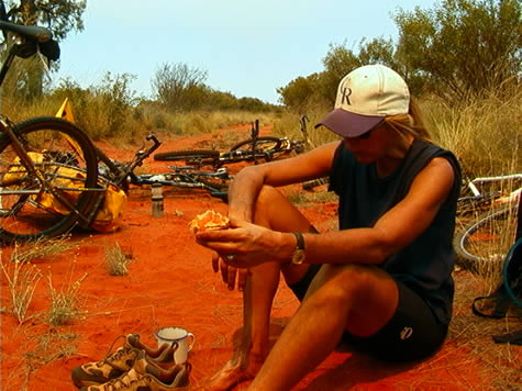
It’s very hard to find anywhere out here in the Tanami Desert that fulfils even one of the above criteria. After a near mutiny at around 1:30 p.m. Thursday afternoon on the Lajamanu Road, when some team members holed themselves up under the shade of a roadside bush and refused to come out until a campsite had been found, Bluedog finally radioed in with the good news that he’d found at least some shade, firewood and a water hole about 6km off the road. With nothing ahead of us by that point in the day save for yet more sun-baked miles of open sandy road leading to perhaps nowhere, we mustered one last effort of the will to push our leaden bikes up the track to the promised land as described over the radio.
It's now Saturday evening and we’re watered and rested in anticipation of an early 6 a.m. start tomorrow morning. The waterhole didn’t exactly fit the waterhole in our minds when first we heard Bluedog’s sales pitch over the radio. Instead of a crystal clear pool of ice-cold river water, we’ve been camped beside a leach infested mud-puddle frequented by cattle, brumbys (wild horses) and a family of white Cockatoos that screech and yell in the early hours of the morning like a pack of belligerent old ladies. We spent most of yesterday and today huddled under the meagre shade afforded by the truck and a tarpaulin stretched to what seems to be the only tree in Northern Australia. Every half an hour we all shunt a few degrees in line with the sun’s trajectory across the sky until the relief of evening comes, with a corresponding abatement of the day’s heat and onset of the soothing night sounds of crickets and birds coming into drink at the waterhole, all of which seems to make life in the Outback tolerable again.
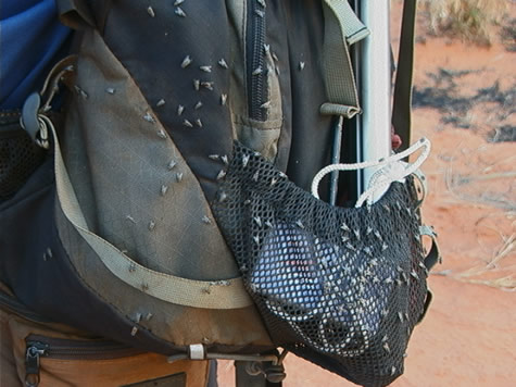
But perhaps the most memorable feature of this camp will be the flies. Burrowing, crawling, wriggling, gnawing flies that laugh in the face of Deet repellent or any other vain attempt to keep them at bay; Hammas flies specially trained in Afghanistan to resist any means of defence until at least one body orifice has been penetrated. Many of us have taken to wrapping muslin around our faces to prevent these things from crawling up our noses and into the sides of our eyes and mouths, with the effect of looking like we’ve taken to wrapping women’s underwear around our heads. The price of fashion is high in the Outback it seems.
So, tomorrow the magnificent eight ride again, escorted by our illustrious life support machine Bluedog. Next stop is Darwin, less than 3-weeks away. It’s strange to think the relative freedom from our usual lives – and all the matters of consequence that go along with them – is so close to coming to an end. And though we complain constantly about the heat, the flies and certain team members’ inability to control their gas, we all know how privileged we are to be out here, blazing a westwards trail each day through country that not many Australians get to see, let alone foreigners from the other side of the world.
Posted at 2:43 PM
September 27, 2001
Overland Australia - Update 54
September 27, 2001
Day 66
10 kilometres west of Lajamanu Community
from Git
If you’ve been reading our updates from the last few days, you’ll know that we recently made a change in our daily routine. We used to wake up, ride (or slog through sand) for eight hours, then find a campsite around 3 p.m., write updates, have dinner, collapse into a heap on the ground somewhere, and call it a day. This schedule works fine if you’re living in, say, Cleveland, or Liverpool, or Nundle, Australia: anywhere except the desert. When, by ten o’clock in the morning, the air has already warmed to 98 (37) degrees, you’d rather eat Vegemite on Weetabix than sweat blood on a bike. After discussing and debating and worrying and planning, we’ve finally managed to put our new plan into action and test it out for a few days.
Our new routine is as follows:
4 a.m. leader for the day wakes up and begins breakfast (light the fire, boil the billy, make porridge, set out peanut butter, jam, damper, Weetabix)
4:30 a.m. leader wakes up the others
4:30-5 a.m. pack up tents/swags/sleeping bags and other personal items and put them in a pile to be loaded on the truck
5-5:30 a.m. enjoy a fabulous porridge and tea when Git’s cooking (or slice it out of the pan with a carving knife if Todd or Josh had a hand in it)
5:45 a.m. load computers, chairs, books, table, food, shovel, personal items, kitchenware, etc, etc, into the truck
6:15 a.m. cycle!
6:30 a.m. enjoy the sun rising on our backs
7 a.m. quick (theoretically anyway) 15 km stretch break
7:15-11 a.m. cycle, taking quick breaks every 15-20 km 11 set up afternoon camp (computers, table, chairs, “kitchen,” tarp for sitting/sleeping) in any shaded area we can find
11:30 a.m. strategy meeting (discussion of the day’s biking logistics; brainstorming for the day’s educational theme; assigning updates to be written) eat mid-morning snack of tea and damper, baked beans, and canned spaghetti
12-2 p.m. write updates, cook afternoon meal, clean what needs cleaning (Crister is not cleaned at this time), fix bikes and tires, nap if you’ve escaped chores 2-3 eat afternoon meal, continue tasks
3-4 p.m. finish tasks, clean up lunch, try to grab a nap
4-7 p.m. cycle again
7 p.m. find campsite, unload the truck, set up computers, chairs, tents, and kitchen, again gather firewood, have second strategy meeting, make evening meal, eat it, clean it up get things ready for the next day: fill water bottles, prepare cycling snacks, repair tires
10-11 p.m. go to sleep
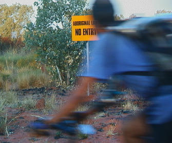
The new schedule saves some sweat and sanity. Occasionally we’ve had to alter our planned routine. Today, for example, we were hard-pressed to find shade alongside the road for our afternoon camp. Since we’re on aboriginal land and are not allowed to trespass by straying too far from the main roads (see geography update), we had to continue cycling until we found a campsite for the night. The new schedule is a great addition to our routine: as we found out today, we’re now prepared for several logistical contingencies.
As of today we’ll be posting a few Aboriginal place-names for you to enjoy each day. As you can see from today’s offerings, they are quite colourful in their English form and more often than not linked by origin to the land and/or people.
COOMALWANGRA: Talking possums
WARDIYALLOCK: Running water
GULLINGARI: To fall from a height
Our educational theme for today is Aboriginal Rights -
CLASSROOM ACTIVITIES >>
Literacy
History
Geography
Posted at 2:40 PM
September 26, 2001
Overland Australia - Update 53
September 26, 2001
Day 65
from April
“This is the most poisonous snake in Australia,” Rex, of the Alice Springs Reptile Centre, informed the group. The Inland Taipan crawled over his boot and between his feet over the tile floor. “Of course, I’ve handled this one each day since I’ve had it,” he reminded us. He then recounted the effects of being bitten by his Eastern Brown a few months earlier. The symptoms were horrific and made one appreciate the availability of today’s anti-venom.
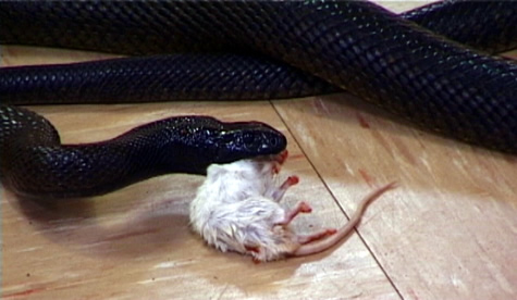
The world's most deadly snake - the Inland Taipan - getting brekky down th nekky
Perhaps the most informative of the Reptile Centre’s program was the part dealing with snake identification. Todd and I had interviewed Rex previously about Australian reptiles and now watched in amazement as he deftly handled the venomous variety, demonstrating for the group feeding techniques for his deadly charges. Opening the front glass case, he held the frozen mouse with tongs about half a metre off the nose of the Eastern Brown that had bitten him. She struck the mouse with such rapidity it wasn’t discernible. If the mouse had been alive, it would’ve been dead within minutes. “Humans are lucky in that, if bitten, they can live up to three days in most instances,” Rex went on matter of factly. “But you need medical attention as soon as you can get it, “ he added.
As Todd and I biked back to the group, we were in thought about what we’d just witnessed, especially the section dealing with snakebite! And, we were about to enter one of the ‘snakiest’ regions along our route! “It makes me think twice about bailing off into the spinifex to pee,” I told him. “Yeah, ignorance isn’t as intimidating as knowing too much, “ he laughed. Thus far, we’d seen hardly a snake the entire route and we’d come through some rather snakey country. But, we are now in the Red Centre, biking through the Tanami Desert, and we’d heard in Hermannsburg that ‘the snakes are out!’
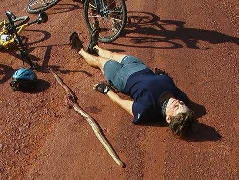
As I gazed up the road outside Rabbit Flat, the lead bikers had stopped in the middle of the road. My initial reaction was that they’d experienced another flat tire. We pulled up alongside and, at that point, I gazed at the longest, fattest snake I’d ever seen in the wild. It was a Western Brown, recently run over, laying outstretched in the road. Mike cautiously opened its mouth with the end of his Bob flag as we peered, fascinated, over his shoulder. We guessed its length at approximately six feet. After taking care of the snake, we headed for Rabbit Flat, quite impressed by the episode.
Yesterday, we had another encounter of a more lively kind. I was leading the group when I biked past the nose of another in the ‘brown snake’ collection! Taken by surprise, I hollered back ‘SNAKE! CAMERAS! SNAKE!” The snake, being rather shy, lay on the road shoulder as Todd and Jason moved in for the camera shot. Suddenly, hit with camera shyness, ‘she’ swivelled around and headed for the brush. Following at a suitable distance, the two moved after her, hoping for a better camera angle. The snake wasn’t too keen to be photographed and took shelter under a bush. Unable to coax her into a better light, we left the snake to continue on our way.
It has become evident that we are now able to put Rex’s excellent information to good use, but hopefully, from a distance!
CLASSROOM ACTIVITIES >>
Science
Literacy
Education for Sustainable Development (ESD)
Posted at 2:39 PM
September 25, 2001
Overland Australia - Update 52
September 25, 2001
Day 64
Tracks
from Mick Roney
Clues left behind. A map. Physical evidence of the existence and movement of a species. These are properties of a track or footprint. Many Australians still consider tracks to be a valuable tool to see into the past, find one's way around and confirm the existence of a specific species and direction it is heading. In fact we have found that our expeditions tracks are the easiest to spot and follow.
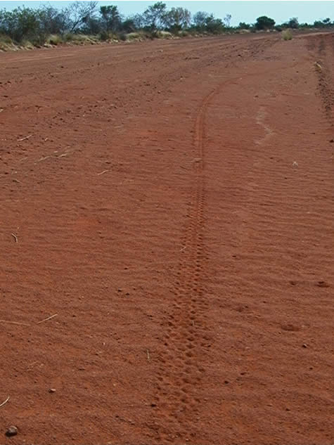
Yes, the unmistakable, but by no means elusive, tracks of the two wheeled “Push-bike rider.” Many have commented that they had come upon our tracks and still could not believe that such a species could exist in the Outback. However, our tracks have substantiated that we are in fact riding our bikes through Australia. It also allows John to find us with the truck before we get too lost.
John has been invaluable in many ways. One has been to teach the art of Tracking to help us find our way as well as to recognize certain animals that may or may not still be lingering around our swags for the night.
Two humbling statements from John came to mind when we had found way too many snake tracks along our ride today. The first was when the riding team came to a dirt cross-roads early on in the trip and stopped to get a GPS fix on which way to go in order to meet John in the truck. We radioed John as to what we were doing and he simply said, “Which road are my truck tracks going?” At that we simply bowed our heads, put the GPS away and up the road we went in awe of this simple but effective way of finding the right track.
The second was yet again when the team was using the fancy GPS gadget and John simply said ”There was a time when people got around quite nicely without such contraptions." Again we were humbled by the truth of his words.
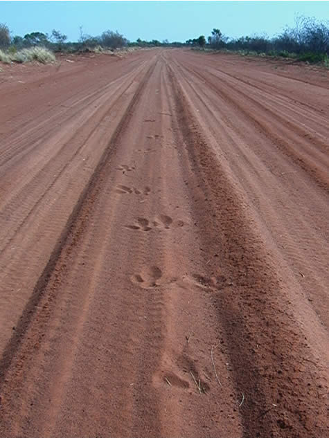
Emu Tracks
Tracking has gotten into all of our blood now. We use it every day. We made it through a huge valley that had not seen humans through it for years without using the high-tech gadgets but instead looked for clues left by people who once created a road through the valley. We always look for John’s tracks and I personally look for certain critter tracks around the campsite before setting my sleeping bag down for the night. See how good a tracker you might be by visiting our educational site and picking out some tracks we found just today.
Find out more about Tracking in the following educational areas:
CLASSROOM ACTIVITIES >>
Maths or Download the lesson as a PDF
Literacy
Environmental Studies
Posted at 2:38 PM
September 24, 2001
Overland Australia - Update 51
September 24, 2001
Day 63
Rabbit Flat Roadhouse on the Tanami Track
From Josh:
During the trip we have met a number of different people. One man we met back in Yuendumu was named Frank. Frank appeared as a laid-back, bare-foot, bush redneck; we soon realized that he was actually as far from being a bush redneck as one can get. He could have entertained the group for hours; unfortunately we met him just before we were ready to leave.
Frank told us that he and an owner of the most remote roadhouse in Australia 420 kms away on the Tanami Track (Bruce at Rabbit Flat Roadhouse), have a 10 year tradition of writing abusive letters to one another and sending them in the most ridiculous ways - for example aeroplane letter drops. One time when Frank attempted to deliver a letter via helicopter the chopper didn’t even have a chance to land. Bruce came out and told the pilot to ‘nick off’ because of all the dust being kicked up by the rotor blades.
I was asked to deliver a letter to Bruce from Frank. Being the type of person I am I gladly accepted the mission. We arrived at Rabbit Flat this morning at around 10.30-11.00am. Bruce was still in bed. I was told to come back in 45minues. I came back and his son said he would be up in about half an hour – “Come back then” I was told.
Just as well we had planned on staying for a while. When he finally came to see me he noticed that Todd was filming the whole episode. Not liking media he asked as politely as he could for us to turn off the camera, “It’s *#@$ impolite to film a man without *#@$ permission.” We turned the camera off and I explained that I had a letter from Frank. He said “that will just be another *#@$ letter telling me to ‘Get Stuffed’.” I told him I knew nothing. He glanced down the letter before turned it for me to read. “I told you so”, he said triumphantly. Sure enough it read the following…
Dear Bruce,
GET STUFFED!!
Love Frank
XXXXXXX
Bruce then walked away without another word. No thank you or anything else. That was the end of my first day with Tanami Bicycle Couriers.
CLASSROOM ACTIVITIES >>
Maths
Geography
Education for Sustainable Development (ESD)
Environmental Studies
Posted at 1:57 PM
September 23, 2001
Overland Australia - Update 50
September 23, 2001
Day 61
From Crister,
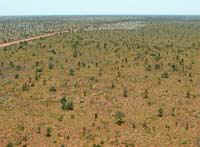
I looked down at my speedo (Australian for speedometer) and saw we still had many miles to do and if we kept our average we’d be there around 3:00 p.m. Then I looked up from my inward little world I’d created (with the simple goal of making kilometres) and took in what was around me…the Tanami Desert! And what a sight it was; beautiful green spinifex stretching for over 100 miles in all directions, dotted with 5-6 foot high ant mounds sloping down gradually in front of me with amazing straightness of track. The early morning light made this sight even more incredible.
The greenness of the spinifex can be attributed to the past three years of good rain that the desert has been given. I feel very lucky to be able to see the Tanami in such a unique state. John, who has spent lots of time in similar climates and landscapes, has told me, that most of the species of plants do not even exist, or lay dormant, without this much rain.
Find out more about the Tanami with the education updates:
- History
- Science
- Information Technology
Crister
The Expedition would like to thank Groupe Sportif who helped out by donating two much needed wheel rims. You can check out their web site at: www.groupesportif.com
CLASSROOM ACTIVITIES >>
Science
IT
History
Posted at 1:54 PM
September 22, 2001
Overland Australia - Update 49
September 22, 2001
Day 61
From April:
The alarm began its annoying beeping. “Damn,” I thought. “4:30 a.m. is much too early to rise, let alone shine.” Camp was beginning to stir, the breakfast fire was burning brightly as figures huddled around it silently drinking billy tea and eating porridge. The team had made the decision the evening before to rise half an hour earlier, thus we’d be biking by 6 a.m. The afternoons for the past couple of days have been quite warm. The thought of rising earlier would have us biking in the cooler part of the day, then quitting earlier in the afternoon as the temperature grows warmer.
Here in the Tanami Desert, it’s hard to imagine that it’s springtime when I base my knowledge of spring weather according to Colorado. (Imagine spring-like conditions where you live. What are the daily highs and lows of temperature?)
As it is the beginning of spring here in the Red Centre, the sun was slow to rise. We rolled out of camp onto the road as the stars began to fade and roadside images began to take shape. Today would be a day to crunch miles up the Tanami Track toward Rabbit Flat.
The cloud cover of the day before was nonexistent today. It had been a wise plan to leave earlier and by 9 a.m. we’d been travelling for over three hours and had 45 kilometres behind us. The sun and the temperature were rising in proportion to one another.
By 1p.m., we’d completed 75 kilometres over the Track’s corrugated surface. The temperature hovered around 35°C (95°F) and I was taking a hard look at ending my bike riding for the day. I knew the team would complete another 20kms before hanging it up. But, some small voice said,“Cowboy up, A, you can do this next bit. Push on so they don’t have to wait on you!”
The team had stopped to film from a higher vantage point, so I hollered at Crister that I would go on ahead so they wouldn’t have to wait on me to struggle along in the heat of the day. Not a wise decision on my part! I know that you don’t leave your team members to set off on your own, but I thought it would be fine as I had the support vehicle up ahead and the rest of the team behind me. Away I ran…
I hit smooth track and made great time. But, I had foolishly not checked my water supply and I was out…I sat down on the road to wait for the rest to catch up… About twenty minutes later, the team arrived. They had to forego their filming opportunity in order to catch up to me to stay together. Conditions in the desert warrant common sense and mine had flown off in the distance. Fortunately, there were no mishaps this time, but I learned an important lesson. And, with six kilometres to go to reach camp, I was not the tail end Charlie!
April
Posted at 1:51 PM
September 21, 2001
Overland Australia - Update 48
September 21, 2001
Day 60
From Crister:
Junior! This is your Pa! Do you read?” Jason said in his pretend Deep South drawl. “ I read Pa…they teach me lots in dem ‘dare schools!” I replied half laughing. Today was a typical slog along the Tanimi track out here in the deep bush.
The flatness and repetitive nature of the Tanimi desert can be in some ways compared to the doldrums (a section of the pacific ocean with little wind or other variety). The corrugations, flat horizon and seemingly unchanging flora that are the Tanami can be a piece of work and a downer to the attitude of all of us in the group.
Fooling around and playing off different jokes throughout the whole trip has been a key to getting through the “hard” sections of the trip. The reason for this is probably because we have the ability to control what we can change; the mood of the group and even our own caricatures. Jason is now my pa, April my ma, and the whole rest of the group, uncles, aunts, and distant cousins. We are a close knit deep south family…This kind of a playful attitude could be seen as an inward way to go about the trip, but I feel that it is because of our laughter that keeps us in good spirits and helps us enjoy and reach out to the people and land that surrounds us.
CLASSROOM ACTIVITIES >>
History
Literacy
Posted at 1:34 PM
September 20, 2001
Overland Australia - Update 47
September 20, 2001
Day 59
From Bel:
Tanami Desert Track, just outside Yuendumu community.
While the team and the truck were waiting, I cycled through Yuendumu
(looking particularly conspicuous because of the BOB trailer) in search of Frank Baarda, a friend of the family who I’d been told I could ask anyone in town for when I showed up, and they’d be able to tell me where he would be.
I found the Yuendumu Mining Company store (which Frank owns) with a little more help from the locals than was absolutely necessary; and had a bizarre, but successful meeting. We wanted to do some filming with an interesting person who could tell us the history of the community, and get an aboriginal perspective on land rights laws.
Our contact, Frank, was the one to point us in the right direction. In under an hour, six people were asleep in the Baarda’s kitchen and living room, and Frank’s wife, Wendy, was telling us the history of the town and finding someone to speak to our cameras.
When riding through the streets the most common sights are rubbish and
dogs. The people of Yuendumu take dogs with them wherever they go. Each
family group is followed by a pack which guards them. Many are sick and
lame, and all are flea-bitten and wormy, but none are strays – all have their place. People call hello and try to stop strangers as they pass, to ask them who they are and what they’re doing; or, to tell what they already know about them through the grapevine.
On my first visit to the Post office - which had been to track down Frank – I squeezed my way into the crowded room, and stood against the back wall, which I thought was the end of a queue. Soon, everyone in the room had turned to look at me, and I was ushered to the front and asked what it was that I wanted.
All of these people were simply socialising! I returned later with Git, to buy post cards and a map, and found the room empty aside from a dingo half-breed asleep underneath one of the benches. After waving to and chatting with several people who passed along behind the counter (and who, on reflection, I think were simply hanging around, and had no more to do with the council administration than we did) a woman approached and asked what we would like.
You can buy stamps at the Yuendumu Post Office, and post a letter if you
don’t mind it being read; but if you need anything else – envelopes,
postcards, maps – you’re in trouble. The postal worker told us that Spring had put an itch into the people there – sent them a little crazy. Because of the level of unemployment, finding something to do all day is a problem, and people lately have been amusing themselves at night by lighting fires. Cars, trucks, buildings – anything will do, just to watch the burning. “Half the town are back there,” she told us, pointing her thumb over her shoulder carelessly, and meaning in the jailhouse.
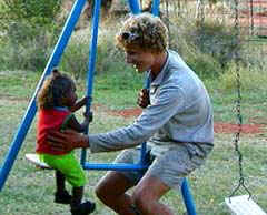
While Jason and Todd were interviewing an aboriginal man in the grounds of a building which looked for all the world like a ruin, I rode back to Wendy and Frank’s house to tell the team how we were getting along. Those who were not napping in the midday sun were petting a pair of baby emus, which had been trapped in the wild and were being raised in a grassy aviary.
Crister and new friend
Jamie, an aboriginal boy of about six years, introduced himself and his brother Jordan, and asked our names. “Have you seen my dog?” He pointed to a mangy looking beast a few yards away. “I have five others,” he added, holding up an outspread hand.
After spending two hours sending out a back-log of website updates by a reluctant Yuendumu internet connection, Jason Git and I met some young
girls who had seen the rest of the team at the Baarda house. They showed
us the remains of a small, though dangerous if provoked, King brown
snake, which the men had caught, then put in a bucket of petrol and set on fire.
As we have found in many places along our route, cyclists are an uncommon sight. The last cyclist who passed through Yuendumu along the Tanami was dressed like a desert dwelling Arabian, and was, apparently, not taken seriously. His story was hopelessly entwined with one Frank told us about a transvestite who had a delusion of a vision of god while on the Tanami Track between there and Rabbit Flat, which is a story for another time.
Bel
Posted at 1:31 PM
September 19, 2001
Overland Australia - Update 46
September 19, 2001
Day 58
Tanami Track, 30km southeast of Yuendumu Northern Territory Australia
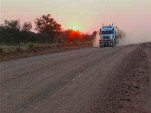
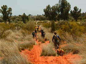
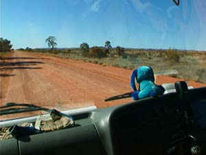
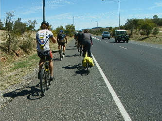
New milestone! After 2.5 days and 80km of ceaseless sweating, sliding and slogging our bikes through spinifex, sand and over at least one snake, we finally shifted scenery. We made it to the infamous Tanami Track, a wide and seemingly endless expanse of bulldust and corrugations. We’d heard so much about it. When we told others it was where we were headed we got head shakes, open guffaws and always, “You’ll never make it!” We were told about the endless, high-speed parades of road trains, the lack of water and firewood, the impassable waves of sand. They gave the impression that we would have a 300km walk on our hands.
Not ones to be daunted by people telling us “you can’t” we continued on as planned, as we always have. Now we’ve arrived and guess what? What everybody has told us thus far is wrong. We’ve seen worse in every category. We’ve only been on the road 27km and we’ve already found a shower with hot and cold running water (as shared by friendly highway workers; our first in about 5 days!). The dust isn’t bad, the road trains infrequent. We were able to cover a third of the distance we’d covered over the past 2.5 days in about 2 hours. It’s all relative.
Had we just come off a sealed road, we’d be cursing under our breath about the corrugations. Instead, after all our recent trials and sweat, some of us can honestly say that we are glad to be on the Tanami. This is just one more example of why you should never let people tell you can’t do something. First of all, they probably have never tried whatever it is or even seen it for themselves. What would they know? Secondly, they might not even know you or what you’ve been through or what your capabilities are. So why are you letting them hold you back?
Todd
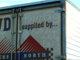
PS. Thanks to a call from her parents on the sat-phone early this morning, we learned of today being Bel’s 20th birthday. Happy birthday to Bel! (Who has maintained for several weeks now that the day is the 1st December). Not being in the immediate vicinity of a card store we had to make do with writing a suitable greeting on the back of the support truck.
Posted at 1:28 PM
September 17, 2001
Overland Australia - Update 45
September 17, 2001
Day 56
Theme for the day: bushfires
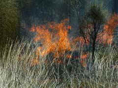
A patch of spinifex burst into flame right next to me! A moment earlier there had only been a small candle-size flame. The bushfire I was watching could be seen from 20 kilometres away as we trudged through the sand….
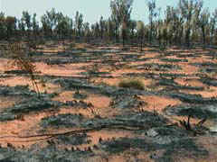
“OW! That hurt!” April yelled as she fell into a large patch of spinifex. The long cactus-like spines had poked her whole right side. The track today was filled with an abundance of overgrown bushes and it was clear that the area had been free to grow wild for many years. Bushfires help clear out the land and are beneficial to the ecosystem if they are done frequently, so they do not burn too hot and wipe out all the flora and fauna.
Slogging through the sand I heard a crackle on the radio and John said, ”There’s a fire ahead and it may be touch and go for you guys to get through.” With that said I was immediately excited and a bit scared. At our smoko, or tea break today we had come within a few hundred feet of the fire! Jason, Todd, Git, Bel, and myself went walkabout to see it up close. From a distance you could tell when a big tree would be hit, or a large bunch of spinifex would light up by the black bellowing smoke going up into the sky. When we got to it the first thing that struck me was the sharp distinction between the previously burnt ground and the awaiting vegetation.
The burnt ground was a cleared section with most trees still standing and was actually quite beautiful! You could tell that this particular fire was not burning too hot, and would help replenish the land in the future. When a patch of spinifex would light up it would burn fast and furious for about 20 seconds and then peter out. It was a neat process to watch and witness. All in all, my previous vision of a raging 40-kph bushfire was changed into a process that is necessary to keep the land healthy. We then left smoko and rode/walked in the sand to camp which was an area burnt out earlier today by the fire. I’ve seen some lizards amongst the Desert Oaks standing in camp, so I know that today’s fire has not burnt too hot, and will help the land in the future.
By, Crister
CLASSROOM ACTIVITIES >>
Science
Maths 1
Maths 2
Education for Sustainable Development (ESD)
Posted at 1:25 PM
September 16, 2001
Overland Australia - Update 44
September 16, 2001
Day 55
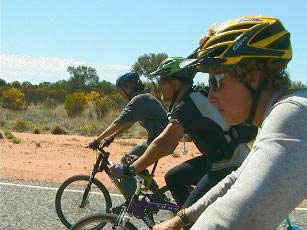
Most of our updates have been showing the bright side of our days. I am going to write about the downfalls. When I first heard about the expedition, all I could imagine was that for the whole duration I would be having fun - partying all the time etc. I was asked on the first day at the Starkey, what I was looking forward to? I was also asked what I wasn’t looking forward to. I considered this for quite some time, and found that I couldn’t answer the question, as I had no thought that any part of the expedition could be physically or mentally challenging. I was wrong.
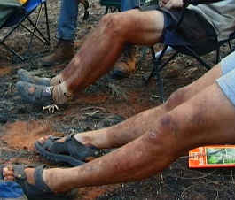
There are many different things that can bring me down for example; three corner jacks that don’t puncture only once but over 13 times, and when you find one hole in your tube and you fix it, then you find the remaining 12 holes. When I told people that I was going on this trip, people would say ‘your going to have so much fun’. Fun sure though, I think that it is more a challenge.
I don’t think any of us have an easy day. One of us must get up at 4.30am in the morning, no-one is allowed to sleep later than 5.30am then we re-pack the truck, get on the bikes and ride for as long as 3pm. Though for me the cycling part of the day is the easiest.
We then set up camp, write updates or cook. Go to bed and repeat the next morning. A point that I don’t think many people who haven’t been in this situation before wouldn’t realise would be that in such a small group and not communicating with many people. Apart from the odd station hand or tourist, managers of historical sites, for example Luke from Hermansburg. This lack of communication can get me down. I hate to relate it to television but if it helps you to understand it could be like “Big brother” a reality tv show, that was on recently where people where locked into a house together. Not knowing each other, and not being able to see their families or communicate with them. The difference is that we can telephone our family and friends when we get into a town with a public phone.
Since I was about 12 years old I have had a dream that I would own a Cannondale mountain bike. When I heard that the company sponsors us, I jumped up and down in excitement. Though being out on the road for a while I became aware that you can have the best of the best equipment; and still be capable of buckling a wheel until it looks like a banana because of rather rough roads. Or get a few punctures from riding through a thorn bush just off the track.
Sand and flies have been my main enemies in the last two days. Our other enemy that no-one would begrudge me of saying I am sure; is that when we get into a town we get a few dirty looks from shopkeepers and clean locals. As we haven’t showered for up to 15 days, leaving a trail of sweat, b o, and dirty sock smells behind us. Not being clean doesn’t help us from feeling good about our selves, let alone the rest of the smelly group. All in all we may be having a challenging time, though by saying it is not fun would be wrong. We are going to remember the best of the best times that we had and will still have along the trip. For example… No I am not even going to bother, there are too many good times. I would be here for the rest of the night. Though most of the views that I write about in this report can’t be seen as the whole groups views. They are my views not the group’s.
Joshua
N.B. We reached our antipodal point today (23.47.00S, 131.22.00E) opposite to a point reached on the Atlantic (23.48.36N, 48.37.37W) by the expedition. Now we head north!
CLASSROOM ACTIVITIES >>
Literacy
Geography
Environmental Studies
Posted at 1:22 PM
September 15, 2001
Overland Australia - Update 43
September 15, 2001
Day 54
A day in the life of Blue Dog- (support crew, outback tucker man, chief cook and bottle washer).
BANG! BANG! BANG! I opened one eye and peered out from beneath my swag cover- sure enough in the firelight I could make out the shadowy form of Mike preparing breakfast assisted by the ever-present Crister when there is work to be done. Dammed cold this morning again but maybe one or two degrees higher than it has been I decided as I struggled into a rare clean pair of jeans.
The porridge is excellent again- (it always has been since I showed everyone the trick of soaking the oats overnight)- the tea though is a little stewed, made a bit early (or am I a little late?) – no it’s only 5:30, have to tell them about that. Roll the swag, into the truck and receive the swags, tents, bags, food, cooking utensils, electronic and camera equipment for nine people and stack it all so the rough roads don’t turn the inside of the pantec into something that has just come out of a kitchen whiz.
Not bad, the truck is packed and ready to roll by 6:50 and Mike (our captain for the day) is briefing the troops on our route – possibly getting back on station tracks again, the first time for the last 5 road days. I felt like a headmaster when I pointed out the dangers of stopping on these roads for a break without considering the fact that a 4,W.D may be coming over a hill around a blind bend at 80km/hr but I didn’t want to feel responsible if something went wrong.
That over and done with, Blue Dog on the dash and I pulled out of camp at 6.55 bound for our first stop at 15km or the clearly marked turnoff at approximately 13 –whichever came first. The corrugations on the loose rocks climbing the first ridge soon had maps, torches, tapes, pens and anything else you would like to name soon came raining down out of the overhead compartments and Blue and I knew we were “back in the bush”. Next thing Blue was on the floor and has to be rescued while missing the potholes and listening to the fading news reception.
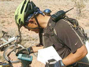
Noticing a few tracks leading off along the way we stopped at 15km and waited. “This is Mike calling Blue Dog- do we turn right at the 13 km mark or did you turn left?” “Blue Dog to Mike. I’m still on the road which goes straight ahead, waiting at 15k’s as ordered” “Blue Dog, I strongly suggest that we should take this turn as depicted on the “topo” map” God, the “topo” map, I’d been listening to the news and only referring to the “big picture” map- maybe I’d missed something! “Err, standby Mike” A quick consultation with the other map showed that he might be right. “Blue Dog is returning to your position”
Mike did indeed turn out to be right but after several hours checking this road that had not been used in many decades contrary to the map I called the Papunya Police Station and spoke with a very helpful officer as to the track to get through to Derwent Station. Armed with this info I called Derwent and received the O.K. from Ian to travel their station track so we proceeded another 15k’s to the turnoff at Stokes Bore. Cross the sandy creek and find a suitable tree to boil the billy under -light a fire, pull out the lunch gear (damper from last night, jam, etc, etc) and meet with Wade passing in a Land Cruiser who works on Derwent station.
The “Brave Soldiers” by this time are all looking a little weary to say the least as the temperature is rising to 30C and there is a high incidence of sand on this little used track. Pack the gear, pull out and head up the road for the most important job of the day- find a Blue Dog Approved 5 Star camp site in the shortest possible distance. Over a low rise, sand, rocks and low scrub – but worst of all, everywhere you look is heavily grassed which makes a campfire impossible. A small open flat on the right at 1.5k’s, maybe but no shade, 2.7k’s we cross a small sandy creek- turn off and do some “scrub bashing” and then jump out leaving Blue Dog to guard the truck against the flies while I check out a likely area on foot. No result in 5mins so on we go. Through some more sand, over a ridge and down to a small gum creek and Bingo! – a nicely trimmed grass area with shade and an ample supply of firewood suitable for the damper.
“Blue Dog to 360, do you read Mike?” “I copy you Blue Dog” “There is a campsite at 3.7k’s from your last position and it rates at 4 Blue Dog Stars” “Sounds good, Blue Dog, we look forward to getting there, Mike out.”
John
Posted at 1:19 PM
September 14, 2001
Overland Australia - Update 42
September 14, 2001
Day 53
Namatjira Drive, West MacDonnel Ranges: Alice Springs, Gosse Bluff, Pupunya Turnoff.
As the eight bicycles wound up a hillock crest which had been signposted as Tyler’s Pass lookout, a radio-communications tower came into view, and I immediately asked: “For how long are we going to stay here?” The answer came, offhandedly: “About half an hour.” I needed no further encouragement. Riding up alongside the high barbed fence, I launched myself over – undeterred by the black and orange sign warning of broadcast frequency radiation within the enclosed area. I approached the base of the mast-like antenna pole, and took a deep breath as I thought of the similar tower we had encountered earlier in the trip, at the abandoned Starke homestead.
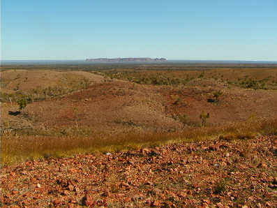
There, the tower’s lowest section had been smooth and featureless for around five times my own height - to deter people from climbing it for their own safety. The ascent had taken some work, but the view had been well worth the effort. Here, the set up was the same, but with an interjecting pipeline, and in a couple of minutes I was gently moving with the breeze which swayed the top of the tower, admiring the 360 degree view, and the circular tessellations of desert vegetation below me.
The jutting blue summits of distant ranges could be seen to the East, while hidden from viewers at ground level by a broad, scallop-patterned mesa like those we had seen in the East MacDonnel Ranges. Turning to the North, the hillocky country we had just entered appeared as evenly undulating spinifex-covered mounds; and the route we were to travel out along was a smooth red line, which snaked away to a vanishing point. Further around, a vast flat desert-scape was broken by a mammoth circle of abrupt peaks - the five-kilometre broad Gosse Bluff meteorite crater.
Formed 140 million years ago, when a kilometre-wide comet struck the earth, destroying all life within a hundred miles; the incredible landform appears quite at home in the surrounding dramatic countryside. Due South, veiled by the drifting smoke of wildfires, lay the road we had crawled along through the morning, constantly stopping to appreciate and film the many attractions of the desert landscape in a time of recent rain. The intoxicating scent of wildflowers accompanied their colourful display: orange, blue, several shades of magenta and pinks, yellows, and delicate white were all represented, our favourites being the Poached Egg Daises and the Silvertails.
We had reached Hermannsburg mission settlement late-morning Wednesday, and spent the day filming and looking around. We then used the early evening to escape the sealed road before setting up a terrific camp in clean bright red sand, surrounded by porcupine spinifex - a punctured truck tyre was a small price to pay for a camp away from the tourist road. This left us with a whole day of wonderfully sandtrappy, rocky, clay track ahead, apart from an incongruous though short stretch of wide, new road seemingly joining nowhere to nowhere. Taking in some native grass trees (and a posing kingfisher), a feral camel, (who challenged Mike to a race, then cheated by cutting suddenly in front of him) breathtaking views, the regular billy-tea break, and several GPS check stops; we covered less than our usual amount of clicks, but took the time to admire them all thoroughly. This afternoon we set up camp number fifty-three, among Blue Mallee and flowering shrubs full of singing honeyeaters. A clear ochre sunset softly silhouetted the eucalypts and left the starshine to see us through until another crescent moonrise just minutes before dawn.
Bel
Posted at 1:17 PM
September 13, 2001
Overland Australia - Update 41
September 13, Day 52
Its amazing how quickly one can slip into a set routine, even in places you least expect it, like out here in the Australian bush. After just a month and a half on the road we know pretty much what we’ll be doing at any point in the day: get up at 5.00am; on the bikes by 7.00; 15km stretch; 15km thumbs up to BlueDog; 15km more and then its morning smoko break.
None of this will mean much to anyone reading this, but to us it’s the system we’ve developed to move 9 people a minimum of 60 kms per day through some pretty inhospitable territory. And it works. But things can get a little samey, even with the amazing country we’re passing through. Today, however, was an exception. Not being big on birthdays I’d tried to keep today being my 34th birthday a secret. But somehow word leaked out and at 5am this morning I found myself being rudely woken by what seemed at first glance to be a posse of out of season carol singers, but on closer inspection through sleep deprived eye-slits proved to be no less that Crister, Git and Bel doing the Happy Birthday thing. But the best was yet to come – breakfast in bed. To some this may not seem to be such a big deal. But in the bush, and especially at that time in the morning when everyone is normally fighting at the feeding trough to fill their bellies with porridge and damper, getting fed by another team member is truly a luxury. First a cup of hot tea was thrust into my hand, followed shortly by a bowl of hot porridge, topped with a healthy dollop of Golden Syrup, and a slice of toast and jam on the side. My, what a spoilt birthday boy was I!
At 6.40 am we found ourselves easing out of camp with a stunning sunrise at our backs, skimming the last 60 kms of bitumen to Hermannsburg where we spent the rest of the day exploring the mission set up by the Lutherans in 1877.
Jason
CLASSROOM ACTIVITIES >>
Maths
Literacy
History
Posted at 1:15 PM
September 12, 2001
Overland Australia - Update 40
September 12
Day 51
From Git:
Red rubble alongside the road again. The bitumen stretches miles in the distance. Pricking thorns cover our campground. Thousands trapped under stone and steel in lower Manhattan.
The sun is setting broadly. It pinks the sky over gidgee branches undulating on a breeze. World Trade Center’s been bombed. It’s lying in a grey and sooty heap. The Pentagon’s half gone, too. Bel tells us she wants to write an educational piece on the Snappy Gum. The Snappy Gum! We have a bit of a laugh. How can I make sense of today’s events in the USA? How can I wake at five in the morning to news of violation and murder, and hear that it’s celebrated jovially in the streets of other countries? How can I get up, eat my porridge, get on a bike, and pedal a highway through Central Australia, when I don’t know where my friends and family in New York were at the time of the blasts?
How can I leave Alice Springs and head into the desert, where I’ll have no further link to telephone, television, or radio for six weeks? How can I be so irresponsible, so selfish, so insensitive, so simple as to think that my presence on the Expedition is of some importance, important enough for me to keep on with it, instead of catching the next plane home? What strange mix of arrogance and naïveté got me on that bike this morning, on the assumption that kids’ being shown the world and its citizens, might teach them to respect their environment and their neighbors? These are rhetorical questions. After several hours of following radio and television news, I did get on that bike. We five Americans in the group saddled up and rode with our international compatriots. We have to believe that what we’re doing makes some small dent in a larger unhappiness. So, around 11 a.m., after a last cup of tea and a final check of the route, we departed from Alice Springs. Onward!
Git
CLASSROOM ACTIVITIES >>
Education for Sustainable Development (ESD)
IT
Posted at 1:14 PM
September 9, 2001
Overland Australia - Update 39
September 9
Day 48
From April:
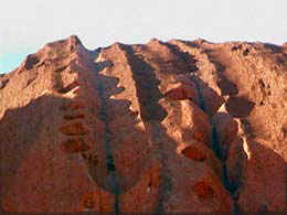
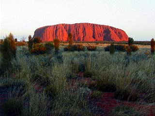
Putting our bikes aside and taking a highly anticipated side-trip, strong head winds slowed our truck’s progress as we laboured south toward Uluru (Ayers Rock). A delayed start to the trip had Jason, Crister, and myself second guessing if we’d make it in time for the sunset, a ‘must see’ for everyone visiting the ‘Red Centre’. At nearly 450 kms from Alice Springs, the odds weren’t in our favour, but we pushed on, fully expecting to experience the dynamic event which is the centrepiece of Australian legend. I must mention the story of Uluru from a geological standpoint as well as its cutural significance would make for great educational material for the kids’ programs. The three of us had elected to endure the five hour trip, one way, making this a quick turn, sunset one evening, then returning to The Alice the next day. Well, things don’t always go according to plan…
As the sun dipped low in the western sky, fingers of light in shades of pinks, reds, and golds pierced the clouds above it. It was one of the most spectacular sunsets we’d seen for days. And, we were twenty minutes too late. Bumper to bumper traffic was LEAVING the park; ours, the only one making its way against the tide, in the dark, toward the rock we were determined to see. The stark outline of Uluru rising over 350 metres above the desert floor, was barely visible against the star-filled sky.
“Well,” sighed Jason, “I suppose we can capture sunrise instead.”
We made our way back to Yulara to find a camping spot for the night. Cold desert air reminded us that we’re still in winter here. Layering all of the clothes we’d brought with us, we crawled into sleeping bags, which would have to keep us till morning.
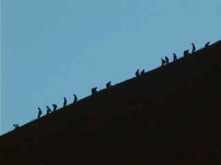
Dawn broke as we circled the base of the gigantic monolith. Many Aboriginal sacred sites, accompanied by stories of the Dream Time, were identified along the path at its base. In contrast, a line of ‘ants’ slowly inched its way up the steep rocky slab toward the summit. “Geez, look at all of those people,” exclaimed Crister in amazement. (I suppose man has a climbing instinct and whenever he encounters something over a few metres high, you can bet someone is going to attempt to scale it.) We continued around the base of the monolith while the line of ‘ants’ scaling Uluru began to dwindle.
Deciding to attempt the climb, we parked the truck and began our ascent. Not a fan of heights, I told the other two that I’d set my own pace and for them not to wait on me. Something about the log chain laying on the rock face, suspended between intermittent metal poles traversing a slab of vertical rock several hundred metres in the air, led me to believe I might not get too far. I began hauling myself up the rock…
While stopping to slow my heart rate and inhaling copious amounts of air, an angelic voice spoke up. “This is the hardest bit and if you go just a ways further, it becomes easier. A lot more fun, too, because you can turn around and see a long way.” The voice belonged to a cherub faced ten year old girl, who was on her way down. “Keep going, you can do it, and you’ll be so proud when you do,” she called over her shoulder. So, grabbing the large chain for security as well as support, I continued toward Jason and Crister, who waited ahead for me. Within an hour, we stood on the summit, staring for many kilometres in all directions.
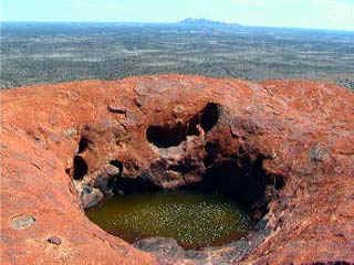
I didn’t feel as if I’d conquered anything. I stood in humble silence, sharing space with a handful of people one thousand feet above the desert floor. It was as if we were compatible with that space given us by the rock. Perhaps the lessons learned for me came from the efforts of our climb, perhaps we were influenced by others making the journey under special circumstances. The three of us descended a couple of hours later, with a different insight for having made the climb. And, did we see the sunset? In a mad dash, returning from The Olgas nearby, in the late afternoon, we did indeed capture a magnificent view of Uluru’s reds in the fading light, giving us yet another vision to take away with us at day’s end.
Posted at 1:09 PM
September 6, 2001
Overland Australia - Update 38
Adelaide House-The first hospital in Central Australia
The building of the first outpost Bush hospital, a “Place for People in Central Australia”, began in January, 1913, the vision of Rev. John Flynn, from Moliagul in Victoria. Flynn’s story of the need for a medical facility in the remote locations of the Outback, prompted a group of Presbyterian children to raise over $1000 toward its completion.
Standing in the doorway of the stone structure, which was completed in 1926, gives a perspective of the project that was undertaken. Preservation of the building as a museum pays tribute to the extraordinary vision of its founder, the architectural design and engineering of its builders, and the selfless toil of the nurses who tended to the populations in the remote areas. The letter I read from a settler on the Finke River to Flynn stated the concerns at the absence of medical help:
“We have been married 11 years and got six children in family. Our first born was a girl…next was a boy born at Charlotte Waters N T where there was no doctor or nurse…I had to do everything myself…The next born was a girl…the wife had to travel 150km…the next was a boy…I had to do everything myself…A man in the bush country with a wife and family deserves a lot of consideration where there are no doctors, nurses, or schools. All we have to help us is medical books…I am only a poor man pulling hard against the stream”
Construction of the hospital was no easy task. World War I was in full swing and fund raising efforts were difficult. By April, 1920, work began on the stone structure. Jack Williams, builder of the local ‘gaol’ (jail) had quarried his own stone and burned the lime for the mortar which formed the foundation and walls. His supply problem was the absence of timber and iron needed as supports for the windows and doors. Sections of the old Ghan railroad line were transported by camels to the Alice for use in the cellar walls. Timber was carted from Oodnadatta by the first available wagon team. Experienced carpenters from Adelaide who could complete the great roof span for the hospital and engine room were commissioned to complete the structure.
Knowing the 1920s was a time period of drought, I was curious to know how patients withstood the heat in the building, which had to be closed up mid day to combat dusty conditions. “Flynn consulted a well known ventilation expert,” the museum guide explained. “The cooling air entered the cellar via a two meter high tunnel under the floor. A zig-zag arrangement of sacking suspended from the roof of the tunnel, to be kept wet in hot weather, cooled the air and filtered out the dust…It was drawn through stone ducts into the wards and evacuated out by convection…through the lantern roof above.” An efficient design, the Architectural Science Unit of the University of Queensland has restored the cooling system to test its suitability for adaption in the hot dry areas of Australia.
In November, 1926, the first successful field radio transmission of a telegram was sent in Australia from the Hermannsberg Mission to Alice, then via Overland Telegraph to Tanunda. The technology to accomplish this came from Rev. Flynn’s partner, Alf Traeger, creator of the Pedal Radio, which was utilized at Adelaide House. This unique device incorporated bicycle pedals to create the power source for transmission. “Hmmm, human powered by bicycle pedals,” I’m thinking! And, all of this from the Engine Room constructed to create power for the hospital as well!
The Bush was no longer completely isolated as a new era had been ushered in. Medical safety and social development through the use of the two-way radio for communication, a field hospital to aid those in medical need, and the newly formed Flying Doctors Service, to administer to emergency cases in the Bush, fulfilled John Flynn’s dream of creating “A Place for People.”
April
Posted at 2:54 PM
September 4, 2001
Overland Australia - Update 37
September 4, 2001
Day 43
From Mick:
We set off early this morning from Trephina Nature Park, where yes terday we had a “true” day off. It was absolutely wonderful. We all went our own ways, either hiking and/or biking through Trephina’s breathtaking park. I don’t believe any of us encountered another soul throughout the day, some- thing quite unusual for a national park.
All of us felt refreshed and all very quiet on the road to Alice Springs this morning. The road was paved in bitumen and spectacular mountain-scapes surrounded us every kilometer. The forces of nature that created these ranges kept all of our attention and made the total distance of 80 kilometers go in the blink of an eye. It was, yet again, a perfect riding day: the wind at our backs; the sun shining a cool 85 degrees F; cadence of 32 kilometers an hour that felt as though you were hardly pedaling at all. And some of the Macdonnell Range’s most amazing sites - you can see without ever leaving bitumen - pulling us onward.
We stopped to look at Corroboree Rock, a significant religious site for the Eastern Arrente tribe. We also stopped for our ‘billy break’ at Jessie Gap, one of a number of cuts in the range caused by the erosive action of rivers flowing north/ south. These and many other parts of the landscape – like the wildflowers lining the roadside - entertained us on our way to Alice Springs, our last ‘town’ as such before reaching Darwin.
FROM APRIL:
The Ross Highway from Trephina Gorge toward Alice Springs was quiet. Bicycle tires whirred along the bitumen surface as we made our way west, past Emily and Jessie Gaps. Perhaps only ten cars had passed us all morning so our safety net of ‘Car Up’ and ‘Car Back’ to identify oncoming traffic was in little use. The bike team seemed especially quiet as we rode, perhaps contemplating our return to settled areas. Each time we’ve approached towns, it seems to be with a bit of trepidation on my part. To leave the remoteness of the Outback with only our little group for company almost always has my experiencing culture shock.
The increase in traffic mixed with a bit of sign pollution encouraging the traveller to ‘SEE THIS!’ or ‘STAY HERE!’ signalled things were about to change. As we drew near the outer limits of Alice Springs, traffic became too thick for ‘Car Up’ and ‘Car Back’ and turned rapidly into ‘Everyman for Himself’! I became slightly overwhelmed, trying to watch for all of the obstacles one has to deal with when riding into town. I gave Crister a wild eyed looked and he commented, “I wonder when we’re leaving?!”
Sidling up next to the curb between the railroad tracks and the Stuart Highway, we waited for all of us to get gathered up before preceding into town. It was at that moment that I heard the dull roar of a locomotive. Not two meters away, The Ghan, the legendary train of the Australian Outback, came thundering past. I was suddenly consumed by the romance of history associated with trains, the rhythmic clicking of the cars on steel rails conjuring up images of 1930s rail travel. Thinking of the historical significance of a town called Alice, the excitement of discoveries that awaited me replaced my initial dread of the adjustment to town life. Yes, this was going to be quite interesting…
April
CLASSROOM ACTIVITIES >>
Maths
Literacy
Geography
Posted at 1:04 PM
September 3, 2001
Overland Australia - Update 36
Day 42 Update
Moon miles…riding at night
Earlier this year when the bike team started corresponding via email on
the planning details of the trip mention was made of riding at night to
avoid the heat of the day. However, since leaving the Starcke River 42
days ago we've settled into a routine of riding during the day, partly
because it's been cooler than we expected - especially now we're in the
middle of the country, far from any maritime influence - and also
because we've been hard pushed to keep up with all the things needed to
get done in an average day. To suddenly change the routine for this
size of group would be a major logistical headache. But yesterday, with a
short 25km hop to Trephina Gorge National Park (where we are now) and
with a layover day intended for the following day, a rare opportunity
was presented to us. And, more to the point, it was FULL MOON!
A few of the team members had earlier voiced some concerns about biking
on off-road surfaces that might be difficult to negotiate safely. I know
for myself having skated a few road sections by night in the US, a worry
would be riding over existing road-kill. More than a few times during my
Trans-American rollerblade marathon I'd gone flying after piling into
the rotting carcass of an armadillo hidden in the shadows. But on the
plus side the route we would be taking was for the most part bitumen,
and the light of the moon was so bright and cloud cover so minimal we
would be able to see any untoward obstacles a long way in advance. So,
at around 8 p.m., with the occasional whoop of expectation punctuating
the night and a generous slice of John's most excellent quiche warming
the inside of our bellies, we stole out from Ross River Homestead under
the cover of darkness to lay down the first moon-miles of the trip.
The experience of biking through an environment totally changes without
light being the primary stimulus. Instead of relying on the sense
perception of sight I found myself tuning into the lesser known
sensations of touch, sound and smell: cutting through parcels of warm
and cold air, the scent of roadside Acacia and Flowering Bloodwood
blending into the sound of crunching gravel under our wheels
accompanied by the backdrop chorus of crickets. The whole group was mute by the
time we reached the turn off to our campsite. Normally we're like mob of
chattering monkeys, reacting and remarking at almost every new thing
that comes across our path. But not tonight. Everyone just stood out on
the road, basking in the milky blue light, rolling the experience
around in their mouths like a fine wine before succumbing to the familiar
bustle and confusion of expedition camp life.
This morning we awoke blinking up at blood red canyon walls that reared
up for 500 metres or more either side of our campsite beside the
Trephina Creek (dry at present). This, our layover day would be spent
doing all those legitimate things we never seem to have time for
normally: like lying in until 7a.m. taking time to eat breakfast
thoroughly before wandering off to explore the area or sitting in camp
catching on journal writing or a host of other chores that seem to
otherwise be semi-permanently on the back-burner. You can find out more
about our day by going to the following sections in EDUCATION:
CLASSROOM ACTIVITIES >>
Environmental Studies
Geography
Science
Posted at 2:11 PM
September 2, 2001
Overland Australia - Update 35
The Path Less Traveled
From April:
As the sun broke over the horizon, the bike team trudged through the deep sand in the dry river bed. We'd left behind the support vehicle which could go no further and would retrace its tracks to get out. We, on the other hand, would move forward past the Chabbana water holes on a trail partially reconnoitered the afternoon before by Todd, Mike, and Crister. "It's not real clear," Crister had commented. "We rode a distance of about 20 kilometers, but only about 6 ks are in the actual direction we need to go. The rest were trails or paths that could've gone on forever, but not in the right direction."
I should mention that after we left the Palmer River/Maytown area, our roads have been rather well defined. Today's route would challenge our navigational skills as it dealt with the unknown. Even local knowledge of the trail hadn't provided us with any 'for sures' as to its travel worthiness.
So, armed with topography maps, a GPS, and a keen sense of adventure, we struck out for the Ross River Homestead 45 kilometers away.
The terrain was quite rugged; deep sand and boulders filled the riverbed as we labored through it. In contrast, steep canyon walls guided our progress, their ancient red vertical slab faces silently observed our passing.
We broke out into a clearing. There before us, shimmering in the early morning light, stretched a body of water. The trail we'd been following, now choked with brush, skirted the water's edge and seemed to disappear into the bush. Obviously, the water had to be crossed.
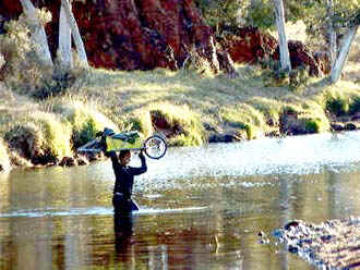
Loaded with packs, then bikes slung over our heads, we began the traverse of the
waist deep water. Its coldness as I settled into it caused me to sharply suck in my breath. "Ah, in true expedition spirit," I thought.
With my bike balanced precariously over my head, I made my way to the opposite
bank. As we progressed along our route, I had begun to notice large piles of dry horse manure. Hmmm, this must be an incredibly large horse or more likely, a small herd running throughout the bush. But, we hadn't seen any livestock, domestic or otherwise.
A day or two earlier, I'd been thinking of a horse story I'd read as a ten year old, "Escape of the Silver Brumby". Set in Australia, it was the romanticised version of a wild horse or brumby, and the countless attempts to capture him. For a ten year old, horse crazy girl, the story fired the imagination. Letting that imagination run wild, I'd recreated the story several times in likely places on this trip. But, to date, the only wild horses I'd seen were in my mind.
Mike's quieted voice broke my train of thought, "April, quick!" he called in a hushed whisper. Standing before us in a break in the trees, three horses were quietly cropping grass. Unaware of our presence, they continued to eat until the crunching of a bike tire brought them to attention. Heads up, manes and tail flying, they made for the brush and were quickly out of sight. My heart was racing with excitement!
We continued on our way, my heart rejoicing at this brief glimpse of another part of Australia's wildness that had impacted me, even as a child. As we topped a rise, I nearly fell off my bike!
A large herd of about 25 brumbies, bays, sorrels, grullos, blacks, spooked up and stampeded before us. On they came, galloping past, circling us before and aft. Three kangaroos, startled by our approach and the galloping horses, joined the flight. We sat there in stunned silence, watching the herd race away as it disappeared over the hill and into the trees.

In this isolated region of the continent, we had been privileged to watch something few people have the chance to experience, perhaps only in a children's book. At that moment in time, capturing the wild horses with their kangaroo mates in flight, there was no place on earth I would rather have been. The rest of the ride into Ross River was quite tame by comparison.
April
__________
From Jason:
Moon miles…riding at night
Earlier this year when the bike team started corresponding via email on the planning details of the trip mention was made of riding at night to avoid the heat of the day. However, since leaving the Starcke River 42 days ago we've settled into a routine of riding during the day, partly because it's been cooler than we expected - especially now we're in the middle of the country, far from any maritime influence - and also because we've been hard pushed to keep up with all the things needed to get done in an average day. To suddenly change the routine for this size of group would be a major logistical headache. But yes- terday, with a short 25km hop to Trephina Gorge National Park (where we are now) and with a layover day intended for the following day, a rare opportunity was presented to us. And, more to the point, it was FULL MOON!
A few of the team members had earlier voiced some concerns about biking on off-road surfaces that might be difficult to negotiate safely. I know for myself having skated a few road sections by night in the US, a worry would be riding over existing road-kill. More than a few times during my Trans-American roller- blade marathon I'd gone flying after piling into the rotting carcass of an armadillo hidden in the shadows. But on the plus side the route we would be taking was for the most part bitumen, and the light of the moon was so bright and cloud cover so minimal we would be able to see any untoward obstacles a long way in ad- vance. So, at around 8 p.m., with the occasional whoop of expectation punc- tuating the night and a generous slice of John's most excellent quiche warming the inside of our bellies, we stole out from Ross River Homestead under the cover of darkness to lay down the first moon-miles of the trip.
The experience of biking through an environment totally changes without light being the primary stimulus. Instead of relying on the sense perception of sight I found myself tuning into the lesser known sensations of touch, sound and smell: cutting through parcels of warm and cold air, the scent of roadside Acacia and Flowering Bloodwood] blending into the sound of crunching gravel under our wheels accompanied by the backdrop chorus of crickets. The whole group was mute by the time we reached the turn off to our campsite. Normally we're like mob of chattering monkeys, reacting and remarking at almost every new thing coming across our path. But not tonight. Everyone just stood out on the road, basking in the milky blue light, rolling the experience around in their mouths like a fine wine before succumbing to the familiar bustle and confusion of expedition camp life.
This morning we awoke blinking up at blood red canyon walls that reared up for 500 metres or more either side of our campsite beside the Trephina Creek (dry at present). This, our layover day would be spent doing all those legitimate things we never seem to have time for normally: like lying in until 7a.m. taking time to eat breakfast thoroughly before wandering off to explore the area or sitting in camp catching on journal writing or a host of other chores that seem to other- wise be semi-permanently on the back-burner. You can find out more about our day by going to the following sections in EDUCATION:
From Bel:
Last night's meeting decided we would not be leaving Ross River early
this morning. Instead we would break camp at dusk this, to ride
to Trephina Gorge Nature Park by moonlight. Beside the usual
organisation of the truck and of our personal business, which delays us
wherever we have access to a laundry and telephone, we were going on a
camel trail ride.
The camel's keeper and our guide, Henry, took us riding on a chain of
bullock camels with names like Sahara, Pishta, and Jose, and was very
informative about the history and biology of his animals. He kept a
running commentary as we rambled leisurely along a low ridge, and gave
us much of the information you'll find in today's educational updates.
CLASSROOM ACTIVITIES >>
Science
History
Education for Sustainable Development (ESD)
Posted at 12:50 PM